You are here: Home > Network List > TX - Texas Seismological Network Stations List
> Station FW09 Farmers Branch > Earthquake Result Viewer
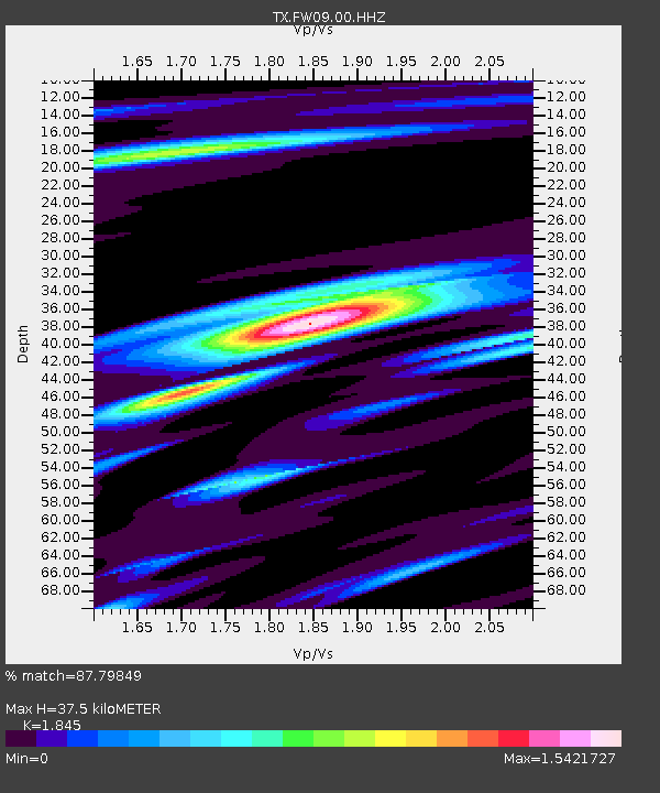
FW09 Farmers Branch - Earthquake Result Viewer
| Earthquake location: |
Ecuador |
| Earthquake latitude/longitude: |
-2.3/-78.9 |
| Earthquake time(UTC): |
2018/09/07 (250) 02:12:04 GMT |
| Earthquake Depth: |
94 km |
| Earthquake Magnitude: |
6.2 Mww |
| Earthquake Catalog/Contributor: |
NEIC PDE/us |
|
| Network: |
TX Texas Seismological Network |
| Station: |
FW09 Farmers Branch |
| Lat/Lon: |
32.92 N/96.91 W |
| Elevation: |
311 m |
|
| Distance: |
39.0 deg |
| Az: |
335.581 deg |
| Baz: |
150.585 deg |
| Ray Param: |
0.074933425 |
| Estimated Moho Depth: |
37.5 km |
| Estimated Crust Vp/Vs: |
1.85 |
| Assumed Crust Vp: |
6.38 km/s |
| Estimated Crust Vs: |
3.458 km/s |
| Estimated Crust Poisson's Ratio: |
0.29 |
|
| Radial Match: |
87.79849 % |
| Radial Bump: |
400 |
| Transverse Match: |
73.75873 % |
| Transverse Bump: |
400 |
| SOD ConfigId: |
2825771 |
| Insert Time: |
2018-09-21 02:30:35.575 +0000 |
| GWidth: |
2.5 |
| Max Bumps: |
400 |
| Tol: |
0.001 |
|

Signal To Noise
| Channel | StoN | STA | LTA |
| TX:FW09:00:HHZ:20180907T02:18:51.249994Z | 6.966847 | 4.8760153E-6 | 6.9988835E-7 |
| TX:FW09:00:HH1:20180907T02:18:51.249994Z | 5.1039248 | 2.8061138E-6 | 5.497953E-7 |
| TX:FW09:00:HH2:20180907T02:18:51.249994Z | 2.0905817 | 1.4499102E-6 | 6.9354394E-7 |
| Arrivals |
| Ps | 5.3 SECOND |
| PpPs | 16 SECOND |
| PsPs/PpSs | 21 SECOND |


