You are here: Home > Network List > CN - Canadian National Seismograph Network Stations List
> Station TAHB Tahsis, BC, CA > Earthquake Result Viewer
TAHB Tahsis, BC, CA - Earthquake Result Viewer
| Earthquake location: |
Near Coast Of Michoacan, Mexico |
| Earthquake latitude/longitude: |
18.2/-103.4 |
| Earthquake time(UTC): |
2022/09/19 (262) 18:05:09 GMT |
| Earthquake Depth: |
10 km |
| Earthquake Magnitude: |
7.5 Mi |
| Earthquake Catalog/Contributor: |
NEIC PDE/at |
|
| Network: |
CN Canadian National Seismograph Network |
| Station: |
TAHB Tahsis, BC, CA |
| Lat/Lon: |
49.89 N/126.68 W |
| Elevation: |
455 m |
|
| Distance: |
36.7 deg |
| Az: |
334.695 deg |
| Baz: |
141.08 deg |
| Ray Param: |
0.07655492 |
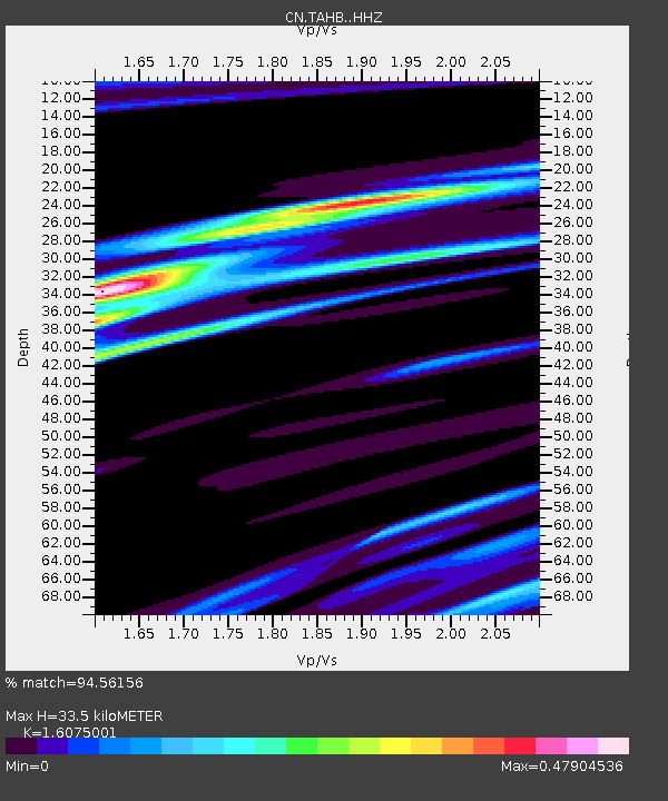
| Estimated Moho Depth: |
33.5 km |
| Estimated Crust Vp/Vs: |
1.61 |
| Assumed Crust Vp: |
6.24 km/s |
| Estimated Crust Vs: |
3.882 km/s |
| Estimated Crust Poisson's Ratio: |
0.18 |
|
| Radial Match: |
94.56156 % |
| Radial Bump: |
156 |
| Transverse Match: |
67.47293 % |
| Transverse Bump: |
400 |
| SOD ConfigId: |
28764291 |
| Insert Time: |
2022-10-03 18:20:14.943 +0000 |
| GWidth: |
2.5 |
| Max Bumps: |
400 |
| Tol: |
0.001 |
|

Signal To Noise
| Channel | StoN | STA | LTA |
| CN:TAHB: :HHZ:20220919T18:11:45.429993Z | 24.768732 | 1.04552255E-5 | 4.2211386E-7 |
| CN:TAHB: :HHN:20220919T18:11:45.429993Z | 9.176653 | 4.792354E-6 | 5.2223334E-7 |
| CN:TAHB: :HHE:20220919T18:11:45.429993Z | 10.919524 | 4.6438536E-6 | 4.2527984E-7 |
| Arrivals |
| Ps | 3.5 SECOND |
| PpPs | 13 SECOND |
| PsPs/PpSs | 16 SECOND |


