You are here: Home > Network List > GS - US Geological Survey Networks Stations List
> Station PR02 PR02, Guayanilla > Earthquake Result Viewer
PR02 PR02, Guayanilla - Earthquake Result Viewer
| Earthquake location: |
Near Coast Of Michoacan, Mexico |
| Earthquake latitude/longitude: |
18.2/-103.4 |
| Earthquake time(UTC): |
2022/09/19 (262) 18:05:09 GMT |
| Earthquake Depth: |
10 km |
| Earthquake Magnitude: |
7.5 Mi |
| Earthquake Catalog/Contributor: |
NEIC PDE/at |
|
| Network: |
GS US Geological Survey Networks |
| Station: |
PR02 PR02, Guayanilla |
| Lat/Lon: |
18.01 N/66.77 W |
| Elevation: |
3.0 m |
|
| Distance: |
34.8 deg |
| Az: |
84.458 deg |
| Baz: |
276.134 deg |
| Ray Param: |
0.07757328 |
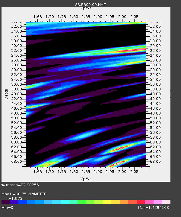
| Estimated Moho Depth: |
68.75 km |
| Estimated Crust Vp/Vs: |
1.98 |
| Assumed Crust Vp: |
5.14 km/s |
| Estimated Crust Vs: |
2.603 km/s |
| Estimated Crust Poisson's Ratio: |
0.33 |
|
| Radial Match: |
87.98256 % |
| Radial Bump: |
400 |
| Transverse Match: |
75.98656 % |
| Transverse Bump: |
400 |
| SOD ConfigId: |
28764291 |
| Insert Time: |
2022-10-03 18:23:09.000 +0000 |
| GWidth: |
2.5 |
| Max Bumps: |
400 |
| Tol: |
0.001 |
|

Signal To Noise
| Channel | StoN | STA | LTA |
| GS:PR02:00:HHZ:20220919T18:11:28.799011Z | 6.4727764 | 1.2122536E-5 | 1.8728493E-6 |
| GS:PR02:00:HH1:20220919T18:11:28.799011Z | 1.5583203 | 4.637828E-6 | 2.9761711E-6 |
| GS:PR02:00:HH2:20220919T18:11:28.799011Z | 2.844352 | 8.135401E-6 | 2.8601949E-6 |
| Arrivals |
| Ps | 14 SECOND |
| PpPs | 38 SECOND |
| PsPs/PpSs | 52 SECOND |


