You are here: Home > Network List > GS - US Geological Survey Networks Stations List
> Station PR05 PR05, Yauco > Earthquake Result Viewer
PR05 PR05, Yauco - Earthquake Result Viewer
| Earthquake location: |
Near Coast Of Michoacan, Mexico |
| Earthquake latitude/longitude: |
18.2/-103.4 |
| Earthquake time(UTC): |
2022/09/19 (262) 18:05:09 GMT |
| Earthquake Depth: |
10 km |
| Earthquake Magnitude: |
7.5 Mi |
| Earthquake Catalog/Contributor: |
NEIC PDE/at |
|
| Network: |
GS US Geological Survey Networks |
| Station: |
PR05 PR05, Yauco |
| Lat/Lon: |
18.05 N/66.86 W |
| Elevation: |
73 m |
|
| Distance: |
34.7 deg |
| Az: |
84.415 deg |
| Baz: |
276.071 deg |
| Ray Param: |
0.0776191 |
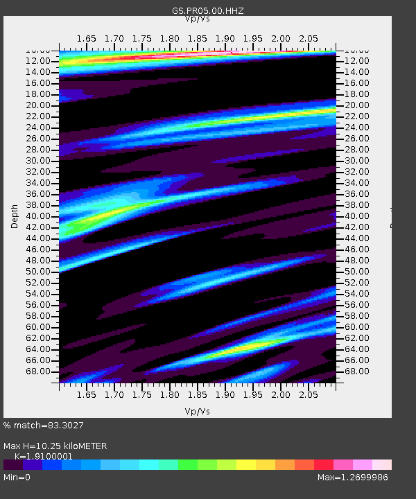
| Estimated Moho Depth: |
10.25 km |
| Estimated Crust Vp/Vs: |
1.91 |
| Assumed Crust Vp: |
5.14 km/s |
| Estimated Crust Vs: |
2.691 km/s |
| Estimated Crust Poisson's Ratio: |
0.31 |
|
| Radial Match: |
83.3027 % |
| Radial Bump: |
308 |
| Transverse Match: |
82.55294 % |
| Transverse Bump: |
400 |
| SOD ConfigId: |
28764291 |
| Insert Time: |
2022-10-03 18:23:10.323 +0000 |
| GWidth: |
2.5 |
| Max Bumps: |
400 |
| Tol: |
0.001 |
|

Signal To Noise
| Channel | StoN | STA | LTA |
| GS:PR05:00:HHZ:20220919T18:11:28.033997Z | 4.9447694 | 1.1771651E-5 | 2.380627E-6 |
| GS:PR05:00:HH1:20220919T18:11:28.033997Z | 1.3554366 | 2.2521606E-6 | 1.6615758E-6 |
| GS:PR05:00:HH2:20220919T18:11:28.033997Z | 3.4887407 | 7.4353675E-6 | 2.1312467E-6 |
| Arrivals |
| Ps | 1.9 SECOND |
| PpPs | 5.6 SECOND |
| PsPs/PpSs | 7.4 SECOND |


