You are here: Home > Network List > IU - Global Seismograph Network (GSN - IRIS/USGS) Stations List
> Station COR Corvallis, Oregon, USA > Earthquake Result Viewer
COR Corvallis, Oregon, USA - Earthquake Result Viewer
| Earthquake location: |
Near Coast Of Michoacan, Mexico |
| Earthquake latitude/longitude: |
18.2/-103.4 |
| Earthquake time(UTC): |
2022/09/19 (262) 18:05:09 GMT |
| Earthquake Depth: |
10 km |
| Earthquake Magnitude: |
7.5 Mi |
| Earthquake Catalog/Contributor: |
NEIC PDE/at |
|
| Network: |
IU Global Seismograph Network (GSN - IRIS/USGS) |
| Station: |
COR Corvallis, Oregon, USA |
| Lat/Lon: |
44.59 N/123.30 W |
| Elevation: |
121 m |
|
| Distance: |
31.1 deg |
| Az: |
331.945 deg |
| Baz: |
141.267 deg |
| Ray Param: |
0.07918492 |
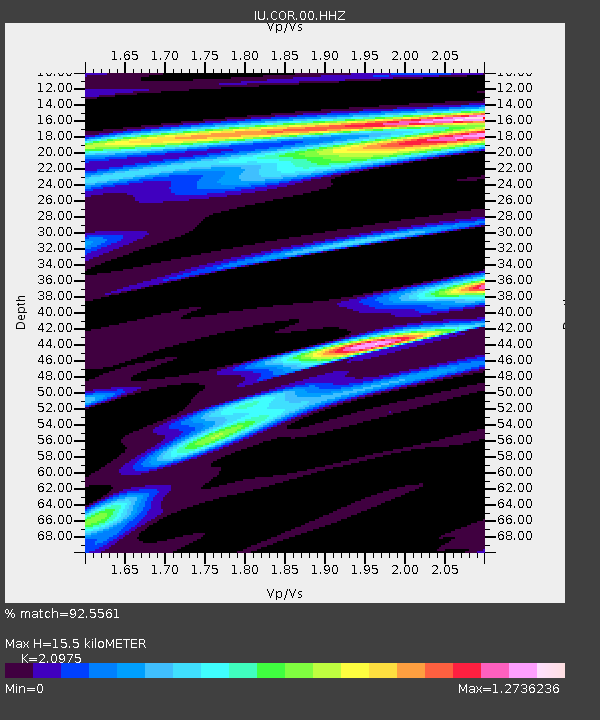
| Estimated Moho Depth: |
15.5 km |
| Estimated Crust Vp/Vs: |
2.10 |
| Assumed Crust Vp: |
6.566 km/s |
| Estimated Crust Vs: |
3.13 km/s |
| Estimated Crust Poisson's Ratio: |
0.35 |
|
| Radial Match: |
92.5561 % |
| Radial Bump: |
388 |
| Transverse Match: |
78.95176 % |
| Transverse Bump: |
400 |
| SOD ConfigId: |
28764291 |
| Insert Time: |
2022-10-03 18:24:05.360 +0000 |
| GWidth: |
2.5 |
| Max Bumps: |
400 |
| Tol: |
0.001 |
|
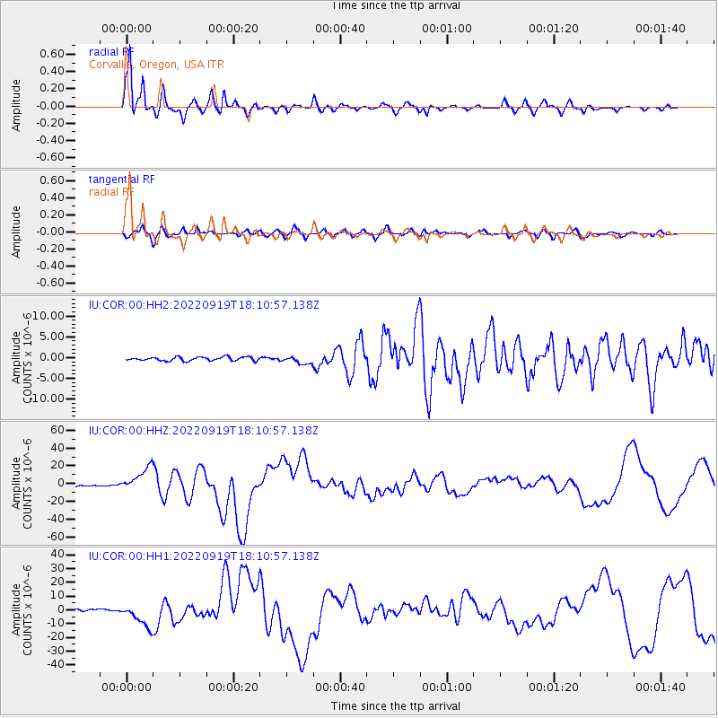
Signal To Noise
| Channel | StoN | STA | LTA |
| IU:COR:00:HHZ:20220919T18:10:57.138Z | 21.796751 | 1.387738E-5 | 6.366719E-7 |
| IU:COR:00:HH1:20220919T18:10:57.138Z | 12.367329 | 8.557754E-6 | 6.9196466E-7 |
| IU:COR:00:HH2:20220919T18:10:57.138Z | 2.003466 | 8.907887E-7 | 4.4462388E-7 |
| Arrivals |
| Ps | 2.8 SECOND |
| PpPs | 6.8 SECOND |
| PsPs/PpSs | 9.6 SECOND |


