You are here: Home > Network List > TX - Texas Seismological Network Stations List
> Station SN01 Snyder 1 > Earthquake Result Viewer
SN01 Snyder 1 - Earthquake Result Viewer
| Earthquake location: |
Ecuador |
| Earthquake latitude/longitude: |
-2.3/-78.9 |
| Earthquake time(UTC): |
2018/09/07 (250) 02:12:04 GMT |
| Earthquake Depth: |
94 km |
| Earthquake Magnitude: |
6.2 Mww |
| Earthquake Catalog/Contributor: |
NEIC PDE/us |
|
| Network: |
TX Texas Seismological Network |
| Station: |
SN01 Snyder 1 |
| Lat/Lon: |
32.86 N/100.89 W |
| Elevation: |
717 m |
|
| Distance: |
40.7 deg |
| Az: |
331.113 deg |
| Baz: |
145.006 deg |
| Ray Param: |
0.07391204 |
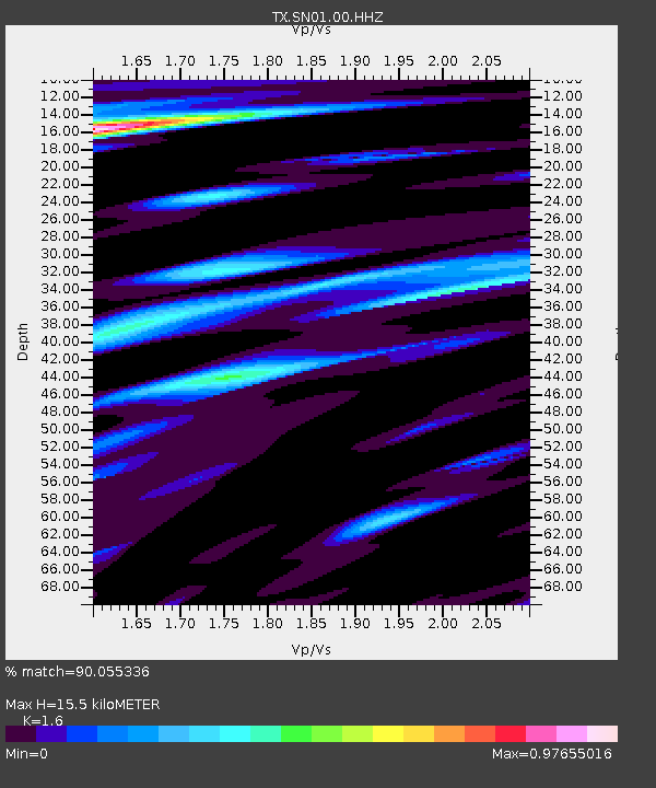
| Estimated Moho Depth: |
15.5 km |
| Estimated Crust Vp/Vs: |
1.60 |
| Assumed Crust Vp: |
6.426 km/s |
| Estimated Crust Vs: |
4.016 km/s |
| Estimated Crust Poisson's Ratio: |
0.18 |
|
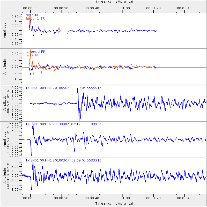
| Radial Match: |
90.055336 % |
| Radial Bump: |
400 |
| Transverse Match: |
81.12738 % |
| Transverse Bump: |
400 |
| SOD ConfigId: |
2825771 |
| Insert Time: |
2018-09-21 02:31:07.144 +0000 |
| GWidth: |
2.5 |
| Max Bumps: |
400 |
| Tol: |
0.001 |
|
Signal To Noise
| Channel | StoN | STA | LTA |
| TX:SN01:00:HHZ:20180907T02:19:05.559991Z | 34.566998 | 5.2827786E-6 | 1.5282724E-7 |
| TX:SN01:00:HH1:20180907T02:19:05.559991Z | 17.214233 | 1.5559409E-6 | 9.0386884E-8 |
| TX:SN01:00:HH2:20180907T02:19:05.559991Z | 16.3829 | 2.1200965E-6 | 1.294091E-7 |
| Arrivals |
| Ps | 1.6 SECOND |
| PpPs | 5.8 SECOND |
| PsPs/PpSs | 7.4 SECOND |


