You are here: Home > Network List > OC - Observatorio Sismológico CIGEOBIO CONICET (OSCO) Stations List
> Station DOCA Don Carmelo > Earthquake Result Viewer
DOCA Don Carmelo - Earthquake Result Viewer
| Earthquake location: |
Near Coast Of Michoacan, Mexico |
| Earthquake latitude/longitude: |
18.2/-103.4 |
| Earthquake time(UTC): |
2022/09/19 (262) 18:05:09 GMT |
| Earthquake Depth: |
10 km |
| Earthquake Magnitude: |
7.5 Mi |
| Earthquake Catalog/Contributor: |
NEIC PDE/at |
|
| Network: |
OC Observatorio Sismológico CIGEOBIO CONICET (OSCO) |
| Station: |
DOCA Don Carmelo |
| Lat/Lon: |
30.94 S/69.08 W |
| Elevation: |
3171 m |
|
| Distance: |
59.0 deg |
| Az: |
145.572 deg |
| Baz: |
321.279 deg |
| Ray Param: |
0.06250822 |
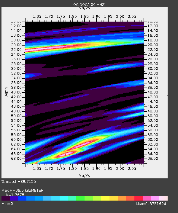
| Estimated Moho Depth: |
66.0 km |
| Estimated Crust Vp/Vs: |
1.77 |
| Assumed Crust Vp: |
6.353 km/s |
| Estimated Crust Vs: |
3.594 km/s |
| Estimated Crust Poisson's Ratio: |
0.26 |
|
| Radial Match: |
89.7155 % |
| Radial Bump: |
381 |
| Transverse Match: |
87.50833 % |
| Transverse Bump: |
400 |
| SOD ConfigId: |
28764291 |
| Insert Time: |
2022-10-03 18:26:06.938 +0000 |
| GWidth: |
2.5 |
| Max Bumps: |
400 |
| Tol: |
0.001 |
|

Signal To Noise
| Channel | StoN | STA | LTA |
| OC:DOCA:00:HHZ:20220919T18:14:37.340027Z | 4.942914 | 1.2890147E-6 | 2.6078033E-7 |
| OC:DOCA:00:HHN:20220919T18:14:37.340027Z | 1.8803254 | 1.0407878E-6 | 5.535147E-7 |
| OC:DOCA:00:HHE:20220919T18:14:37.340027Z | 2.3357725 | 1.4890369E-6 | 6.3749224E-7 |
| Arrivals |
| Ps | 8.4 SECOND |
| PpPs | 27 SECOND |
| PsPs/PpSs | 36 SECOND |


