You are here: Home > Network List > TD - TransAlta Monitoring Network Stations List
> Station TD007 Z > Earthquake Result Viewer
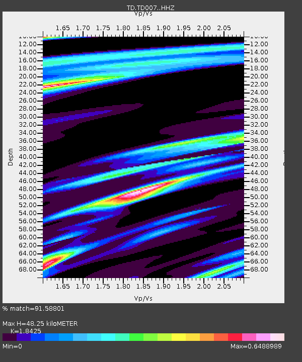
TD007 Z - Earthquake Result Viewer
| Earthquake location: |
Near Coast Of Michoacan, Mexico |
| Earthquake latitude/longitude: |
18.2/-103.4 |
| Earthquake time(UTC): |
2022/09/19 (262) 18:05:09 GMT |
| Earthquake Depth: |
10 km |
| Earthquake Magnitude: |
7.5 Mi |
| Earthquake Catalog/Contributor: |
NEIC PDE/at |
|
| Network: |
TD TransAlta Monitoring Network |
| Station: |
TD007 Z |
| Lat/Lon: |
52.91 N/115.62 W |
| Elevation: |
988 m |
|
| Distance: |
35.9 deg |
| Az: |
347.384 deg |
| Baz: |
159.953 deg |
| Ray Param: |
0.07697618 |
| Estimated Moho Depth: |
48.25 km |
| Estimated Crust Vp/Vs: |
1.84 |
| Assumed Crust Vp: |
6.426 km/s |
| Estimated Crust Vs: |
3.488 km/s |
| Estimated Crust Poisson's Ratio: |
0.29 |
|
| Radial Match: |
91.58801 % |
| Radial Bump: |
273 |
| Transverse Match: |
70.5227 % |
| Transverse Bump: |
288 |
| SOD ConfigId: |
28764291 |
| Insert Time: |
2022-10-03 18:29:00.236 +0000 |
| GWidth: |
2.5 |
| Max Bumps: |
400 |
| Tol: |
0.001 |
|

Signal To Noise
| Channel | StoN | STA | LTA |
| TD:TD007: :HHZ:20220919T18:11:38.660004Z | 31.046295 | 8.64856E-6 | 2.785698E-7 |
| TD:TD007: :HH1:20220919T18:11:38.660004Z | 1.2560124 | 2.948918E-7 | 2.3478415E-7 |
| TD:TD007: :HH2:20220919T18:11:38.660004Z | 11.167137 | 4.2822567E-6 | 3.834695E-7 |
| Arrivals |
| Ps | 6.8 SECOND |
| PpPs | 20 SECOND |
| PsPs/PpSs | 27 SECOND |


