You are here: Home > Network List > UO - University of Oregon Regional Network Stations List
> Station GROV Forest Grove, OR, USA > Earthquake Result Viewer
GROV Forest Grove, OR, USA - Earthquake Result Viewer
| Earthquake location: |
Near Coast Of Michoacan, Mexico |
| Earthquake latitude/longitude: |
18.2/-103.4 |
| Earthquake time(UTC): |
2022/09/19 (262) 18:05:09 GMT |
| Earthquake Depth: |
10 km |
| Earthquake Magnitude: |
7.5 Mi |
| Earthquake Catalog/Contributor: |
NEIC PDE/at |
|
| Network: |
UO University of Oregon Regional Network |
| Station: |
GROV Forest Grove, OR, USA |
| Lat/Lon: |
45.54 N/123.16 W |
| Elevation: |
99 m |
|
| Distance: |
31.8 deg |
| Az: |
333.226 deg |
| Baz: |
142.463 deg |
| Ray Param: |
0.078923464 |
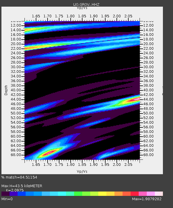
| Estimated Moho Depth: |
43.5 km |
| Estimated Crust Vp/Vs: |
2.10 |
| Assumed Crust Vp: |
6.566 km/s |
| Estimated Crust Vs: |
3.13 km/s |
| Estimated Crust Poisson's Ratio: |
0.35 |
|
| Radial Match: |
84.51154 % |
| Radial Bump: |
296 |
| Transverse Match: |
71.80782 % |
| Transverse Bump: |
400 |
| SOD ConfigId: |
28764291 |
| Insert Time: |
2022-10-03 18:29:23.984 +0000 |
| GWidth: |
2.5 |
| Max Bumps: |
400 |
| Tol: |
0.001 |
|

Signal To Noise
| Channel | StoN | STA | LTA |
| UO:GROV: :HHZ:20220919T18:11:03.149994Z | 17.267647 | 1.3006453E-5 | 7.5322674E-7 |
| UO:GROV: :HHN:20220919T18:11:03.149994Z | 6.229646 | 5.7673183E-6 | 9.2578586E-7 |
| UO:GROV: :HHE:20220919T18:11:03.149994Z | 7.7440863 | 5.260302E-6 | 6.79267E-7 |
| Arrivals |
| Ps | 7.8 SECOND |
| PpPs | 19 SECOND |
| PsPs/PpSs | 27 SECOND |


