You are here: Home > Network List > US - United States National Seismic Network Stations List
> Station HAWA Hanford, Washington, USA > Earthquake Result Viewer
HAWA Hanford, Washington, USA - Earthquake Result Viewer

| Earthquake location: |
Near Coast Of Michoacan, Mexico |
| Earthquake latitude/longitude: |
18.2/-103.4 |
| Earthquake time(UTC): |
2022/09/19 (262) 18:05:09 GMT |
| Earthquake Depth: |
10 km |
| Earthquake Magnitude: |
7.5 Mi |
| Earthquake Catalog/Contributor: |
NEIC PDE/at |
|
| Network: |
US United States National Seismic Network |
| Station: |
HAWA Hanford, Washington, USA |
| Lat/Lon: |
46.39 N/119.53 W |
| Elevation: |
364 m |
|
| Distance: |
31.1 deg |
| Az: |
338.153 deg |
| Baz: |
149.264 deg |
| Ray Param: |
0.07919468 |
| Estimated Moho Depth: |
20.25 km |
| Estimated Crust Vp/Vs: |
2.10 |
| Assumed Crust Vp: |
6.419 km/s |
| Estimated Crust Vs: |
3.06 km/s |
| Estimated Crust Poisson's Ratio: |
0.35 |
|
| Radial Match: |
94.7186 % |
| Radial Bump: |
241 |
| Transverse Match: |
71.44086 % |
| Transverse Bump: |
400 |
| SOD ConfigId: |
28764291 |
| Insert Time: |
2022-10-03 18:30:23.600 +0000 |
| GWidth: |
2.5 |
| Max Bumps: |
400 |
| Tol: |
0.001 |
|
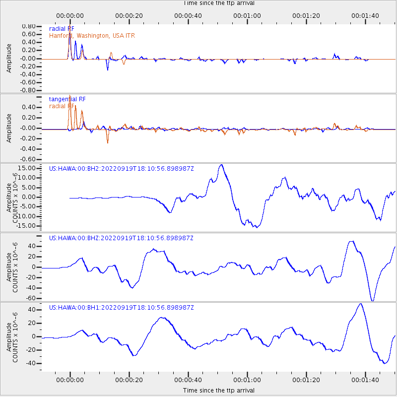
Signal To Noise
| Channel | StoN | STA | LTA |
| US:HAWA:00:BHZ:20220919T18:10:56.898987Z | 33.607033 | 1.2153099E-5 | 3.6162368E-7 |
| US:HAWA:00:BH1:20220919T18:10:56.898987Z | 15.459302 | 6.7935516E-6 | 4.3944752E-7 |
| US:HAWA:00:BH2:20220919T18:10:56.898987Z | 15.189164 | 4.917852E-6 | 3.2377372E-7 |
| Arrivals |
| Ps | 3.7 SECOND |
| PpPs | 9.1 SECOND |
| PsPs/PpSs | 13 SECOND |


