You are here: Home > Network List > UW - Pacific Northwest Regional Seismic Network Stations List
> Station DAVN Davenport, WA, USA > Earthquake Result Viewer
DAVN Davenport, WA, USA - Earthquake Result Viewer
| Earthquake location: |
Near Coast Of Michoacan, Mexico |
| Earthquake latitude/longitude: |
18.2/-103.4 |
| Earthquake time(UTC): |
2022/09/19 (262) 18:05:09 GMT |
| Earthquake Depth: |
10 km |
| Earthquake Magnitude: |
7.5 Mi |
| Earthquake Catalog/Contributor: |
NEIC PDE/at |
|
| Network: |
UW Pacific Northwest Regional Seismic Network |
| Station: |
DAVN Davenport, WA, USA |
| Lat/Lon: |
47.80 N/118.27 W |
| Elevation: |
483 m |
|
| Distance: |
31.9 deg |
| Az: |
340.901 deg |
| Baz: |
152.525 deg |
| Ray Param: |
0.07888233 |
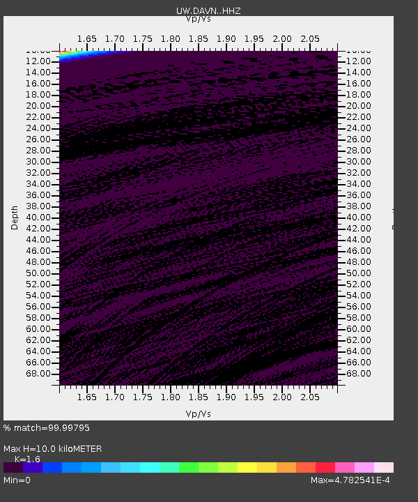
| Estimated Moho Depth: |
10.0 km |
| Estimated Crust Vp/Vs: |
1.60 |
| Assumed Crust Vp: |
6.419 km/s |
| Estimated Crust Vs: |
4.012 km/s |
| Estimated Crust Poisson's Ratio: |
0.18 |
|
| Radial Match: |
99.99795 % |
| Radial Bump: |
2 |
| Transverse Match: |
55.64266 % |
| Transverse Bump: |
400 |
| SOD ConfigId: |
28764291 |
| Insert Time: |
2022-10-03 18:30:49.785 +0000 |
| GWidth: |
2.5 |
| Max Bumps: |
400 |
| Tol: |
0.001 |
|

Signal To Noise
| Channel | StoN | STA | LTA |
| UW:DAVN: :HHZ:20220919T18:11:04.040009Z | 69.84184 | 1.3765984E-5 | 1.9710224E-7 |
| UW:DAVN: :HHN:20220919T18:11:04.040009Z | 51.952824 | 8.060537E-6 | 1.5515108E-7 |
| UW:DAVN: :HHE:20220919T18:11:04.040009Z | 25.447247 | 4.376759E-6 | 1.7199342E-7 |
| Arrivals |
| Ps | 1.0 SECOND |
| PpPs | 3.7 SECOND |
| PsPs/PpSs | 4.7 SECOND |


