You are here: Home > Network List > UW - Pacific Northwest Regional Seismic Network Stations List
> Station HOPR Tall Timber Retreat WA > Earthquake Result Viewer
HOPR Tall Timber Retreat WA - Earthquake Result Viewer
| Earthquake location: |
Near Coast Of Michoacan, Mexico |
| Earthquake latitude/longitude: |
18.2/-103.4 |
| Earthquake time(UTC): |
2022/09/19 (262) 18:05:09 GMT |
| Earthquake Depth: |
10 km |
| Earthquake Magnitude: |
7.5 Mi |
| Earthquake Catalog/Contributor: |
NEIC PDE/at |
|
| Network: |
UW Pacific Northwest Regional Seismic Network |
| Station: |
HOPR Tall Timber Retreat WA |
| Lat/Lon: |
47.92 N/120.89 W |
| Elevation: |
597 m |
|
| Distance: |
32.9 deg |
| Az: |
338.152 deg |
| Baz: |
148.267 deg |
| Ray Param: |
0.07845144 |
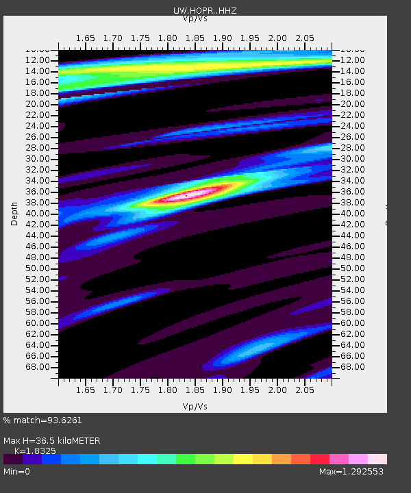
| Estimated Moho Depth: |
36.5 km |
| Estimated Crust Vp/Vs: |
1.83 |
| Assumed Crust Vp: |
6.597 km/s |
| Estimated Crust Vs: |
3.6 km/s |
| Estimated Crust Poisson's Ratio: |
0.29 |
|
| Radial Match: |
93.6261 % |
| Radial Bump: |
277 |
| Transverse Match: |
76.33617 % |
| Transverse Bump: |
400 |
| SOD ConfigId: |
28764291 |
| Insert Time: |
2022-10-03 18:31:19.662 +0000 |
| GWidth: |
2.5 |
| Max Bumps: |
400 |
| Tol: |
0.001 |
|

Signal To Noise
| Channel | StoN | STA | LTA |
| UW:HOPR: :HHZ:20220919T18:11:12.579987Z | 41.0029 | 1.38913765E-5 | 3.387901E-7 |
| UW:HOPR: :HHN:20220919T18:11:12.579987Z | 26.571737 | 7.6838E-6 | 2.8917188E-7 |
| UW:HOPR: :HHE:20220919T18:11:12.579987Z | 20.457882 | 5.0211656E-6 | 2.4543917E-7 |
| Arrivals |
| Ps | 5.0 SECOND |
| PpPs | 14 SECOND |
| PsPs/PpSs | 19 SECOND |


