You are here: Home > Network List > UW - Pacific Northwest Regional Seismic Network Stations List
> Station RPW2 RPW2, Rockport WA > Earthquake Result Viewer
RPW2 RPW2, Rockport WA - Earthquake Result Viewer
| Earthquake location: |
Near Coast Of Michoacan, Mexico |
| Earthquake latitude/longitude: |
18.2/-103.4 |
| Earthquake time(UTC): |
2022/09/19 (262) 18:05:09 GMT |
| Earthquake Depth: |
10 km |
| Earthquake Magnitude: |
7.5 Mi |
| Earthquake Catalog/Contributor: |
NEIC PDE/at |
|
| Network: |
UW Pacific Northwest Regional Seismic Network |
| Station: |
RPW2 RPW2, Rockport WA |
| Lat/Lon: |
48.44 N/121.53 W |
| Elevation: |
694 m |
|
| Distance: |
33.6 deg |
| Az: |
338.003 deg |
| Baz: |
147.673 deg |
| Ray Param: |
0.078160696 |
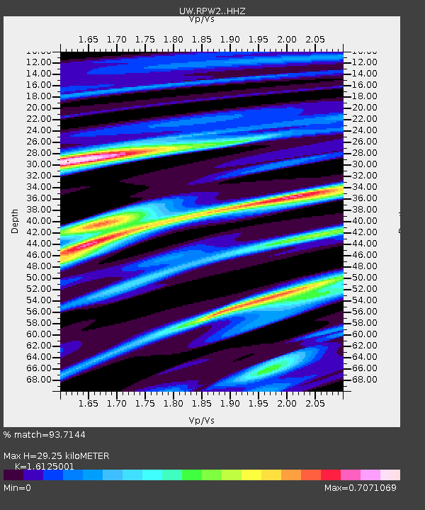
| Estimated Moho Depth: |
29.25 km |
| Estimated Crust Vp/Vs: |
1.61 |
| Assumed Crust Vp: |
6.566 km/s |
| Estimated Crust Vs: |
4.072 km/s |
| Estimated Crust Poisson's Ratio: |
0.19 |
|
| Radial Match: |
93.7144 % |
| Radial Bump: |
312 |
| Transverse Match: |
79.46033 % |
| Transverse Bump: |
400 |
| SOD ConfigId: |
28764291 |
| Insert Time: |
2022-10-03 18:32:12.176 +0000 |
| GWidth: |
2.5 |
| Max Bumps: |
400 |
| Tol: |
0.001 |
|

Signal To Noise
| Channel | StoN | STA | LTA |
| UW:RPW2: :HHZ:20220919T18:11:18.390015Z | 34.257263 | 1.267564E-5 | 3.7001323E-7 |
| UW:RPW2: :HHN:20220919T18:11:18.390015Z | 20.35212 | 6.916539E-6 | 3.3984367E-7 |
| UW:RPW2: :HHE:20220919T18:11:18.390015Z | 16.419813 | 4.1678036E-6 | 2.5382772E-7 |
| Arrivals |
| Ps | 3.0 SECOND |
| PpPs | 11 SECOND |
| PsPs/PpSs | 14 SECOND |


