You are here: Home > Network List > US - United States National Seismic Network Stations List
> Station AMTX Amarillo, Texas, USA > Earthquake Result Viewer
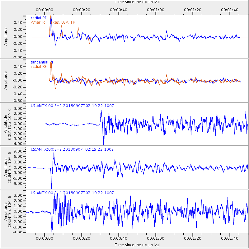
AMTX Amarillo, Texas, USA - Earthquake Result Viewer
*The percent match for this event was below the threshold and hence no stack was calculated.
| Earthquake location: |
Ecuador |
| Earthquake latitude/longitude: |
-2.3/-78.9 |
| Earthquake time(UTC): |
2018/09/07 (250) 02:12:04 GMT |
| Earthquake Depth: |
94 km |
| Earthquake Magnitude: |
6.2 Mww |
| Earthquake Catalog/Contributor: |
NEIC PDE/us |
|
| Network: |
US United States National Seismic Network |
| Station: |
AMTX Amarillo, Texas, USA |
| Lat/Lon: |
34.53 N/101.41 W |
| Elevation: |
1010 m |
|
| Distance: |
42.3 deg |
| Az: |
332.011 deg |
| Baz: |
145.391 deg |
| Ray Param: |
$rayparam |
*The percent match for this event was below the threshold and hence was not used in the summary stack. |
|
| Radial Match: |
86.72688 % |
| Radial Bump: |
400 |
| Transverse Match: |
70.64623 % |
| Transverse Bump: |
400 |
| SOD ConfigId: |
2825771 |
| Insert Time: |
2018-09-21 02:32:02.398 +0000 |
| GWidth: |
2.5 |
| Max Bumps: |
400 |
| Tol: |
0.001 |
|
Signal To Noise
| Channel | StoN | STA | LTA |
| US:AMTX:00:BHZ:20180907T02:19:22.100Z | 24.762848 | 3.433103E-6 | 1.3863927E-7 |
| US:AMTX:00:BH1:20180907T02:19:22.100Z | 9.748669 | 1.1472974E-6 | 1.17687605E-7 |
| US:AMTX:00:BH2:20180907T02:19:22.100Z | 6.3208375 | 8.6623083E-7 | 1.3704368E-7 |
| Arrivals |
| Ps | |
| PpPs | |
| PsPs/PpSs | |


