You are here: Home > Network List > UW - Pacific Northwest Regional Seismic Network Stations List
> Station TBLMT Table Mt, Ellensburg, WA, USA > Earthquake Result Viewer
TBLMT Table Mt, Ellensburg, WA, USA - Earthquake Result Viewer
| Earthquake location: |
Near Coast Of Michoacan, Mexico |
| Earthquake latitude/longitude: |
18.2/-103.4 |
| Earthquake time(UTC): |
2022/09/19 (262) 18:05:09 GMT |
| Earthquake Depth: |
10 km |
| Earthquake Magnitude: |
7.5 Mi |
| Earthquake Catalog/Contributor: |
NEIC PDE/at |
|
| Network: |
UW Pacific Northwest Regional Seismic Network |
| Station: |
TBLMT Table Mt, Ellensburg, WA, USA |
| Lat/Lon: |
47.17 N/120.60 W |
| Elevation: |
1088 m |
|
| Distance: |
32.2 deg |
| Az: |
337.734 deg |
| Baz: |
148.133 deg |
| Ray Param: |
0.07878388 |
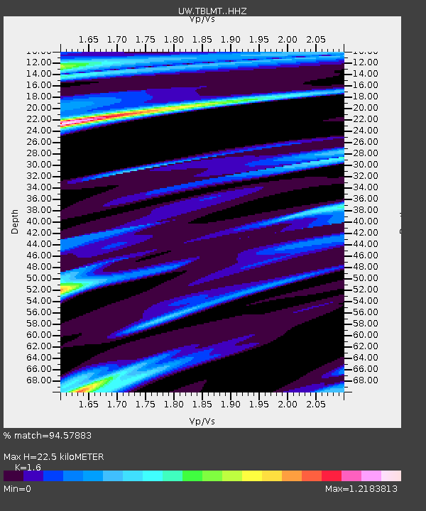
| Estimated Moho Depth: |
22.5 km |
| Estimated Crust Vp/Vs: |
1.60 |
| Assumed Crust Vp: |
6.597 km/s |
| Estimated Crust Vs: |
4.123 km/s |
| Estimated Crust Poisson's Ratio: |
0.18 |
|
| Radial Match: |
94.57883 % |
| Radial Bump: |
254 |
| Transverse Match: |
83.42658 % |
| Transverse Bump: |
400 |
| SOD ConfigId: |
28764291 |
| Insert Time: |
2022-10-03 18:32:59.780 +0000 |
| GWidth: |
2.5 |
| Max Bumps: |
400 |
| Tol: |
0.001 |
|

Signal To Noise
| Channel | StoN | STA | LTA |
| UW:TBLMT: :HHZ:20220919T18:11:06.089996Z | 47.227562 | 1.4893464E-5 | 3.1535532E-7 |
| UW:TBLMT: :HHN:20220919T18:11:06.089996Z | 18.816492 | 7.102031E-6 | 3.774365E-7 |
| UW:TBLMT: :HHE:20220919T18:11:06.089996Z | 20.392275 | 5.06791E-6 | 2.4852108E-7 |
| Arrivals |
| Ps | 2.2 SECOND |
| PpPs | 8.1 SECOND |
| PsPs/PpSs | 10 SECOND |


