You are here: Home > Network List > UW - Pacific Northwest Regional Seismic Network Stations List
> Station ETW Entiat, WA, USA > Earthquake Result Viewer
ETW Entiat, WA, USA - Earthquake Result Viewer
| Earthquake location: |
Near Coast Of Michoacan, Mexico |
| Earthquake latitude/longitude: |
18.2/-103.4 |
| Earthquake time(UTC): |
2022/09/19 (262) 18:05:09 GMT |
| Earthquake Depth: |
10 km |
| Earthquake Magnitude: |
7.5 Mi |
| Earthquake Catalog/Contributor: |
NEIC PDE/at |
|
| Network: |
UW Pacific Northwest Regional Seismic Network |
| Station: |
ETW Entiat, WA, USA |
| Lat/Lon: |
47.60 N/120.33 W |
| Elevation: |
1469 m |
|
| Distance: |
32.4 deg |
| Az: |
338.444 deg |
| Baz: |
148.928 deg |
| Ray Param: |
0.07866485 |
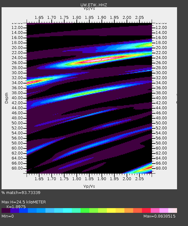
| Estimated Moho Depth: |
24.5 km |
| Estimated Crust Vp/Vs: |
1.90 |
| Assumed Crust Vp: |
6.597 km/s |
| Estimated Crust Vs: |
3.477 km/s |
| Estimated Crust Poisson's Ratio: |
0.31 |
|
| Radial Match: |
93.73339 % |
| Radial Bump: |
193 |
| Transverse Match: |
86.13989 % |
| Transverse Bump: |
400 |
| SOD ConfigId: |
28764291 |
| Insert Time: |
2022-10-03 18:33:23.417 +0000 |
| GWidth: |
2.5 |
| Max Bumps: |
400 |
| Tol: |
0.001 |
|

Signal To Noise
| Channel | StoN | STA | LTA |
| UW:ETW: :HHZ:20220919T18:11:08.48999Z | 52.51747 | 1.4393905E-5 | 2.740784E-7 |
| UW:ETW: :HHN:20220919T18:11:08.48999Z | 59.635624 | 8.505844E-6 | 1.4263024E-7 |
| UW:ETW: :HHE:20220919T18:11:08.48999Z | 35.510174 | 6.7664346E-6 | 1.9054919E-7 |
| Arrivals |
| Ps | 3.6 SECOND |
| PpPs | 10.0 SECOND |
| PsPs/PpSs | 14 SECOND |


