You are here: Home > Network List > WI - West Indies IPGP Network Stations List
> Station MAGL Barre de l'ile, Marie-Galante, Guadeloupe > Earthquake Result Viewer
MAGL Barre de l'ile, Marie-Galante, Guadeloupe - Earthquake Result Viewer

| Earthquake location: |
Near Coast Of Michoacan, Mexico |
| Earthquake latitude/longitude: |
18.2/-103.4 |
| Earthquake time(UTC): |
2022/09/19 (262) 18:05:09 GMT |
| Earthquake Depth: |
10 km |
| Earthquake Magnitude: |
7.5 Mi |
| Earthquake Catalog/Contributor: |
NEIC PDE/at |
|
| Network: |
WI West Indies IPGP Network |
| Station: |
MAGL Barre de l'ile, Marie-Galante, Guadeloupe |
| Lat/Lon: |
15.95 N/61.28 W |
| Elevation: |
159 m |
|
| Distance: |
40.3 deg |
| Az: |
86.623 deg |
| Baz: |
279.448 deg |
| Ray Param: |
0.0745028 |
| Estimated Moho Depth: |
13.75 km |
| Estimated Crust Vp/Vs: |
1.60 |
| Assumed Crust Vp: |
5.88 km/s |
| Estimated Crust Vs: |
3.675 km/s |
| Estimated Crust Poisson's Ratio: |
0.18 |
|
| Radial Match: |
91.56175 % |
| Radial Bump: |
400 |
| Transverse Match: |
79.747025 % |
| Transverse Bump: |
397 |
| SOD ConfigId: |
28764291 |
| Insert Time: |
2022-10-03 18:34:34.230 +0000 |
| GWidth: |
2.5 |
| Max Bumps: |
400 |
| Tol: |
0.001 |
|
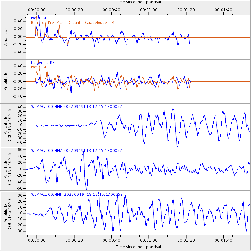
Signal To Noise
| Channel | StoN | STA | LTA |
| WI:MAGL:00:HHZ:20220919T18:12:15.130005Z | 14.542933 | 1.5474763E-5 | 1.0640744E-6 |
| WI:MAGL:00:HHN:20220919T18:12:15.130005Z | 3.1698637 | 2.4005199E-6 | 7.572943E-7 |
| WI:MAGL:00:HHE:20220919T18:12:15.130005Z | 8.023384 | 8.549649E-6 | 1.0655913E-6 |
| Arrivals |
| Ps | 1.5 SECOND |
| PpPs | 5.7 SECOND |
| PsPs/PpSs | 7.2 SECOND |


