You are here: Home > Network List > AK - Alaska Regional Network Stations List
> Station PS06 TAPS Pump Station 6, AK, USA > Earthquake Result Viewer
PS06 TAPS Pump Station 6, AK, USA - Earthquake Result Viewer
| Earthquake location: |
Near Coast Of Michoacan, Mexico |
| Earthquake latitude/longitude: |
18.5/-103.5 |
| Earthquake time(UTC): |
2022/09/20 (263) 08:17:16 GMT |
| Earthquake Depth: |
54 km |
| Earthquake Magnitude: |
5.8 mww |
| Earthquake Catalog/Contributor: |
NEIC PDE/us |
|
| Network: |
AK Alaska Regional Network |
| Station: |
PS06 TAPS Pump Station 6, AK, USA |
| Lat/Lon: |
65.85 N/149.74 W |
| Elevation: |
280 m |
|
| Distance: |
56.1 deg |
| Az: |
339.047 deg |
| Baz: |
124.4 deg |
| Ray Param: |
0.06421184 |
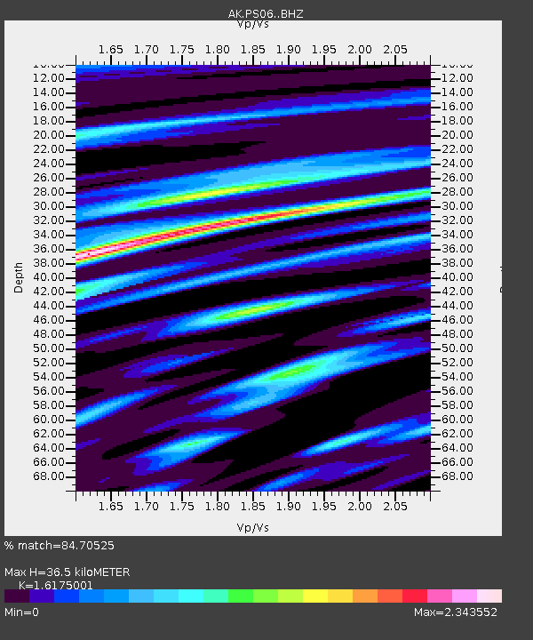
| Estimated Moho Depth: |
36.5 km |
| Estimated Crust Vp/Vs: |
1.62 |
| Assumed Crust Vp: |
6.566 km/s |
| Estimated Crust Vs: |
4.059 km/s |
| Estimated Crust Poisson's Ratio: |
0.19 |
|
| Radial Match: |
84.70525 % |
| Radial Bump: |
400 |
| Transverse Match: |
60.406464 % |
| Transverse Bump: |
400 |
| SOD ConfigId: |
28764291 |
| Insert Time: |
2022-10-04 08:22:58.354 +0000 |
| GWidth: |
2.5 |
| Max Bumps: |
400 |
| Tol: |
0.001 |
|

Signal To Noise
| Channel | StoN | STA | LTA |
| AK:PS06: :BHZ:20220920T08:26:20.128021Z | 9.792862 | 6.179389E-7 | 6.3100956E-8 |
| AK:PS06: :BHN:20220920T08:26:20.128021Z | 4.527729 | 3.8928027E-7 | 8.597694E-8 |
| AK:PS06: :BHE:20220920T08:26:20.128021Z | 6.3271804 | 4.7255048E-7 | 7.468579E-8 |
| Arrivals |
| Ps | 3.6 SECOND |
| PpPs | 14 SECOND |
| PsPs/PpSs | 17 SECOND |


