You are here: Home > Network List > AV - Alaska Volcano Observatory Stations List
> Station SPNN North Nagishlamina, Mount Spurr, Alaska > Earthquake Result Viewer
SPNN North Nagishlamina, Mount Spurr, Alaska - Earthquake Result Viewer
| Earthquake location: |
Near Coast Of Michoacan, Mexico |
| Earthquake latitude/longitude: |
18.5/-103.5 |
| Earthquake time(UTC): |
2022/09/20 (263) 08:17:16 GMT |
| Earthquake Depth: |
54 km |
| Earthquake Magnitude: |
5.8 mww |
| Earthquake Catalog/Contributor: |
NEIC PDE/us |
|
| Network: |
AV Alaska Volcano Observatory |
| Station: |
SPNN North Nagishlamina, Mount Spurr, Alaska |
| Lat/Lon: |
61.37 N/152.70 W |
| Elevation: |
1666 m |
|
| Distance: |
54.9 deg |
| Az: |
333.547 deg |
| Baz: |
118.631 deg |
| Ray Param: |
0.065008536 |
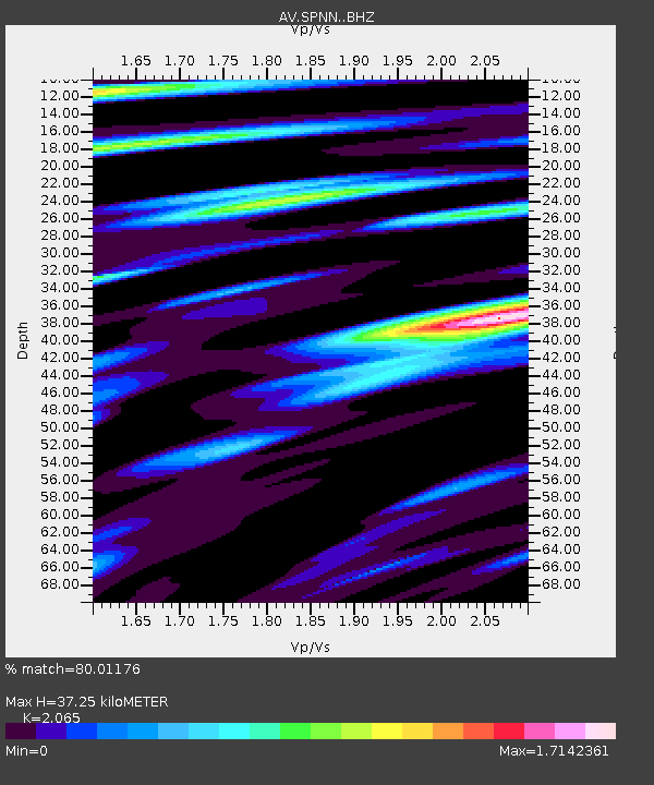
| Estimated Moho Depth: |
37.25 km |
| Estimated Crust Vp/Vs: |
2.07 |
| Assumed Crust Vp: |
6.566 km/s |
| Estimated Crust Vs: |
3.18 km/s |
| Estimated Crust Poisson's Ratio: |
0.35 |
|
| Radial Match: |
80.01176 % |
| Radial Bump: |
400 |
| Transverse Match: |
76.04079 % |
| Transverse Bump: |
400 |
| SOD ConfigId: |
28764291 |
| Insert Time: |
2022-10-04 08:25:37.403 +0000 |
| GWidth: |
2.5 |
| Max Bumps: |
400 |
| Tol: |
0.001 |
|

Signal To Noise
| Channel | StoN | STA | LTA |
| AV:SPNN: :BHZ:20220920T08:26:11.339997Z | 13.548716 | 7.7265855E-7 | 5.7028178E-8 |
| AV:SPNN: :BHN:20220920T08:26:11.339997Z | 5.512859 | 2.8624424E-7 | 5.1923013E-8 |
| AV:SPNN: :BHE:20220920T08:26:11.339997Z | 5.619542 | 2.980709E-7 | 5.304185E-8 |
| Arrivals |
| Ps | 6.3 SECOND |
| PpPs | 17 SECOND |
| PsPs/PpSs | 23 SECOND |


