You are here: Home > Network List > CN - Canadian National Seismograph Network Stations List
> Station INK INUVIK, NT > Earthquake Result Viewer
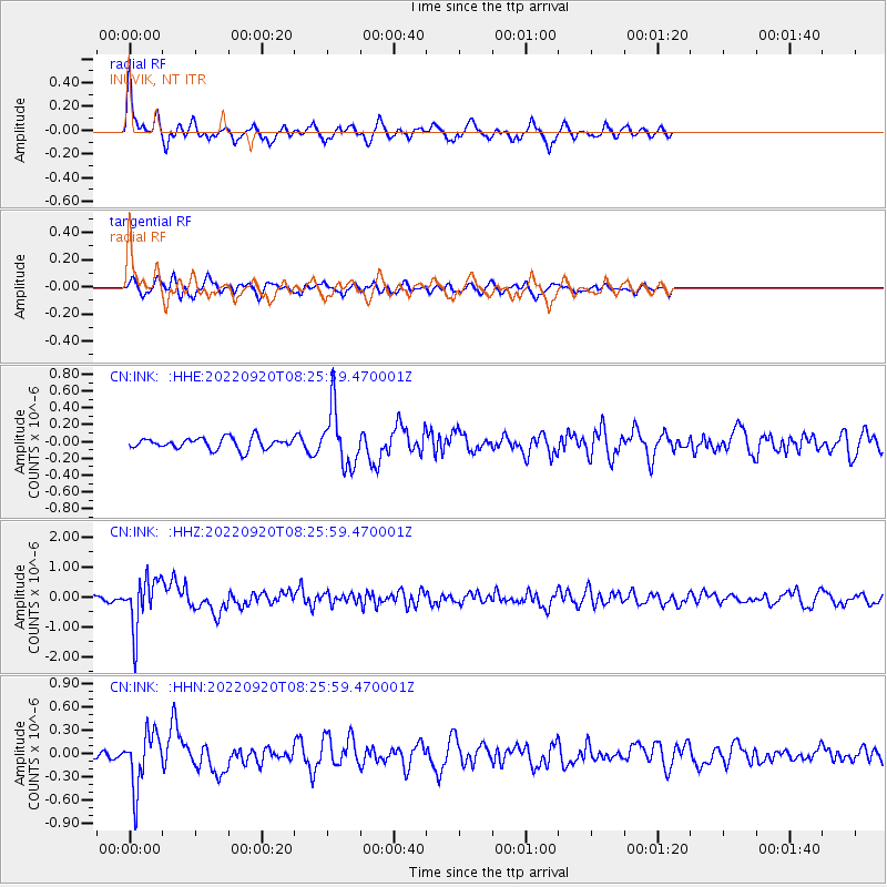
INK INUVIK, NT - Earthquake Result Viewer
*The percent match for this event was below the threshold and hence no stack was calculated.
| Earthquake location: |
Near Coast Of Michoacan, Mexico |
| Earthquake latitude/longitude: |
18.5/-103.5 |
| Earthquake time(UTC): |
2022/09/20 (263) 08:17:16 GMT |
| Earthquake Depth: |
54 km |
| Earthquake Magnitude: |
5.8 mww |
| Earthquake Catalog/Contributor: |
NEIC PDE/us |
|
| Network: |
CN Canadian National Seismograph Network |
| Station: |
INK INUVIK, NT |
| Lat/Lon: |
68.31 N/133.53 W |
| Elevation: |
44 m |
|
| Distance: |
53.3 deg |
| Az: |
346.59 deg |
| Baz: |
143.699 deg |
| Ray Param: |
$rayparam |
*The percent match for this event was below the threshold and hence was not used in the summary stack. |
|
| Radial Match: |
77.30444 % |
| Radial Bump: |
327 |
| Transverse Match: |
58.842705 % |
| Transverse Bump: |
400 |
| SOD ConfigId: |
28764291 |
| Insert Time: |
2022-10-04 08:29:53.191 +0000 |
| GWidth: |
2.5 |
| Max Bumps: |
400 |
| Tol: |
0.001 |
|
Signal To Noise
| Channel | StoN | STA | LTA |
| CN:INK: :HHZ:20220920T08:25:59.470001Z | 7.2730985 | 8.386773E-7 | 1.1531225E-7 |
| CN:INK: :HHN:20220920T08:25:59.470001Z | 5.054705 | 3.5812957E-7 | 7.085073E-8 |
| CN:INK: :HHE:20220920T08:25:59.470001Z | 4.982939 | 3.3684262E-7 | 6.759919E-8 |
| Arrivals |
| Ps | |
| PpPs | |
| PsPs/PpSs | |


