You are here: Home > Network List > G - GEOSCOPE Stations List
> Station MPG Montagne des Peres, French Guyana > Earthquake Result Viewer
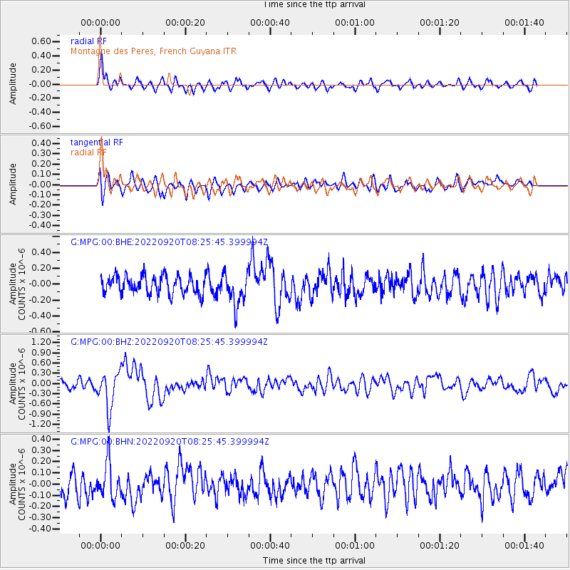
MPG Montagne des Peres, French Guyana - Earthquake Result Viewer
*The percent match for this event was below the threshold and hence no stack was calculated.
| Earthquake location: |
Near Coast Of Michoacan, Mexico |
| Earthquake latitude/longitude: |
18.5/-103.5 |
| Earthquake time(UTC): |
2022/09/20 (263) 08:17:16 GMT |
| Earthquake Depth: |
54 km |
| Earthquake Magnitude: |
5.8 mww |
| Earthquake Catalog/Contributor: |
NEIC PDE/us |
|
| Network: |
G GEOSCOPE |
| Station: |
MPG Montagne des Peres, French Guyana |
| Lat/Lon: |
5.11 N/52.64 W |
| Elevation: |
147 m |
|
| Distance: |
51.4 deg |
| Az: |
98.387 deg |
| Baz: |
289.497 deg |
| Ray Param: |
$rayparam |
*The percent match for this event was below the threshold and hence was not used in the summary stack. |
|
| Radial Match: |
73.04813 % |
| Radial Bump: |
400 |
| Transverse Match: |
62.040955 % |
| Transverse Bump: |
400 |
| SOD ConfigId: |
28764291 |
| Insert Time: |
2022-10-04 08:32:46.042 +0000 |
| GWidth: |
2.5 |
| Max Bumps: |
400 |
| Tol: |
0.001 |
|
Signal To Noise
| Channel | StoN | STA | LTA |
| G:MPG:00:BHZ:20220920T08:25:45.399994Z | 3.9395761 | 5.5088145E-7 | 1.3983266E-7 |
| G:MPG:00:BHN:20220920T08:25:45.399994Z | 1.7006981 | 1.6205806E-7 | 9.528913E-8 |
| G:MPG:00:BHE:20220920T08:25:45.399994Z | 1.8733416 | 2.1013055E-7 | 1.12168834E-7 |
| Arrivals |
| Ps | |
| PpPs | |
| PsPs/PpSs | |


