You are here: Home > Network List > UW - Pacific Northwest Regional Seismic Network Stations List
> Station DAVN Davenport, WA, USA > Earthquake Result Viewer
DAVN Davenport, WA, USA - Earthquake Result Viewer

| Earthquake location: |
Near Coast Of Michoacan, Mexico |
| Earthquake latitude/longitude: |
18.5/-103.5 |
| Earthquake time(UTC): |
2022/09/20 (263) 08:17:16 GMT |
| Earthquake Depth: |
54 km |
| Earthquake Magnitude: |
5.8 mww |
| Earthquake Catalog/Contributor: |
NEIC PDE/us |
|
| Network: |
UW Pacific Northwest Regional Seismic Network |
| Station: |
DAVN Davenport, WA, USA |
| Lat/Lon: |
47.80 N/118.27 W |
| Elevation: |
483 m |
|
| Distance: |
31.6 deg |
| Az: |
340.902 deg |
| Baz: |
152.574 deg |
| Ray Param: |
0.07889086 |
| Estimated Moho Depth: |
61.75 km |
| Estimated Crust Vp/Vs: |
1.90 |
| Assumed Crust Vp: |
6.419 km/s |
| Estimated Crust Vs: |
3.37 km/s |
| Estimated Crust Poisson's Ratio: |
0.31 |
|
| Radial Match: |
99.71212 % |
| Radial Bump: |
44 |
| Transverse Match: |
42.972813 % |
| Transverse Bump: |
396 |
| SOD ConfigId: |
28764291 |
| Insert Time: |
2022-10-04 08:40:35.466 +0000 |
| GWidth: |
2.5 |
| Max Bumps: |
400 |
| Tol: |
0.001 |
|
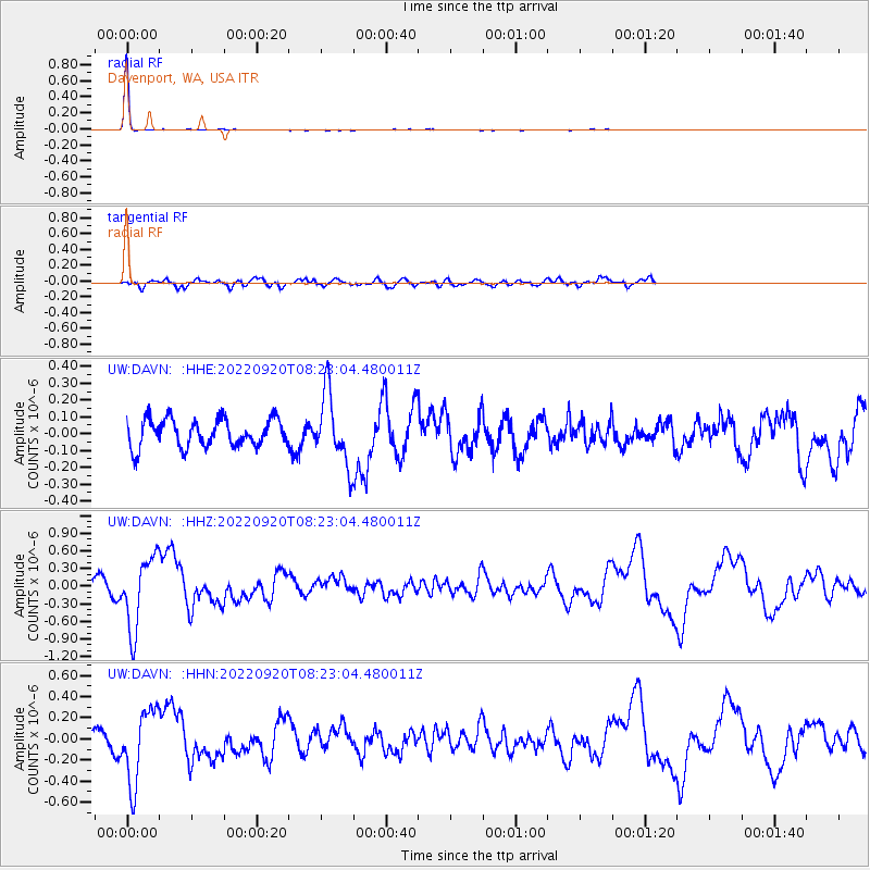
Signal To Noise
| Channel | StoN | STA | LTA |
| UW:DAVN: :HHZ:20220920T08:23:04.480011Z | 5.4490147 | 6.049901E-7 | 1.11027425E-7 |
| UW:DAVN: :HHN:20220920T08:23:04.480011Z | 4.7832503 | 3.466933E-7 | 7.2480695E-8 |
| UW:DAVN: :HHE:20220920T08:23:04.480011Z | 2.4940999 | 2.0626545E-7 | 8.270136E-8 |
| Arrivals |
| Ps | 9.4 SECOND |
| PpPs | 26 SECOND |
| PsPs/PpSs | 35 SECOND |


