You are here: Home > Network List > UW - Pacific Northwest Regional Seismic Network Stations List
> Station PASS Maple Falls, WA, USA > Earthquake Result Viewer
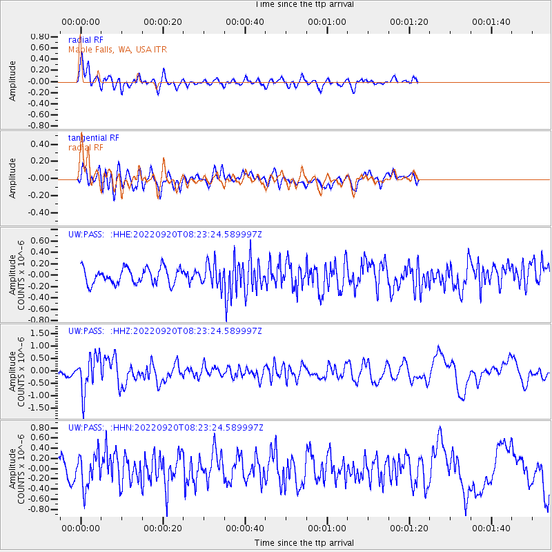
PASS Maple Falls, WA, USA - Earthquake Result Viewer
*The percent match for this event was below the threshold and hence no stack was calculated.
| Earthquake location: |
Near Coast Of Michoacan, Mexico |
| Earthquake latitude/longitude: |
18.5/-103.5 |
| Earthquake time(UTC): |
2022/09/20 (263) 08:17:16 GMT |
| Earthquake Depth: |
54 km |
| Earthquake Magnitude: |
5.8 mww |
| Earthquake Catalog/Contributor: |
NEIC PDE/us |
|
| Network: |
UW Pacific Northwest Regional Seismic Network |
| Station: |
PASS Maple Falls, WA, USA |
| Lat/Lon: |
49.00 N/122.09 W |
| Elevation: |
174 m |
|
| Distance: |
33.9 deg |
| Az: |
337.954 deg |
| Baz: |
147.253 deg |
| Ray Param: |
$rayparam |
*The percent match for this event was below the threshold and hence was not used in the summary stack. |
|
| Radial Match: |
72.600464 % |
| Radial Bump: |
400 |
| Transverse Match: |
62.30219 % |
| Transverse Bump: |
400 |
| SOD ConfigId: |
28764291 |
| Insert Time: |
2022-10-04 08:41:33.531 +0000 |
| GWidth: |
2.5 |
| Max Bumps: |
400 |
| Tol: |
0.001 |
|
Signal To Noise
| Channel | StoN | STA | LTA |
| UW:PASS: :HHZ:20220920T08:23:24.589997Z | 4.5706563 | 7.201558E-7 | 1.5756069E-7 |
| UW:PASS: :HHN:20220920T08:23:24.589997Z | 2.2508214 | 3.2514407E-7 | 1.4445574E-7 |
| UW:PASS: :HHE:20220920T08:23:24.589997Z | 1.4023482 | 1.9463705E-7 | 1.3879367E-7 |
| Arrivals |
| Ps | |
| PpPs | |
| PsPs/PpSs | |


