You are here: Home > Network List > CC - Cascade Chain Volcano Monitoring Stations List
> Station LOO Loowit > Earthquake Result Viewer
LOO Loowit - Earthquake Result Viewer
| Earthquake location: |
Komandorskiye Ostrova Region |
| Earthquake latitude/longitude: |
55.5/166.3 |
| Earthquake time(UTC): |
2022/09/20 (263) 18:23:42 GMT |
| Earthquake Depth: |
10 km |
| Earthquake Magnitude: |
6.0 mww |
| Earthquake Catalog/Contributor: |
NEIC PDE/us |
|
| Network: |
CC Cascade Chain Volcano Monitoring |
| Station: |
LOO Loowit |
| Lat/Lon: |
46.22 N/122.18 W |
| Elevation: |
1521 m |
|
| Distance: |
44.2 deg |
| Az: |
70.917 deg |
| Baz: |
309.295 deg |
| Ray Param: |
0.07210769 |
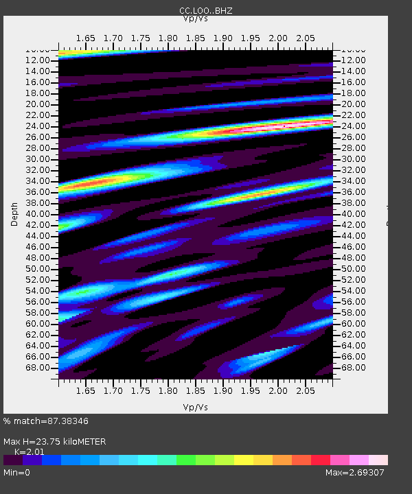
| Estimated Moho Depth: |
23.75 km |
| Estimated Crust Vp/Vs: |
2.01 |
| Assumed Crust Vp: |
6.566 km/s |
| Estimated Crust Vs: |
3.267 km/s |
| Estimated Crust Poisson's Ratio: |
0.34 |
|
| Radial Match: |
87.38346 % |
| Radial Bump: |
400 |
| Transverse Match: |
82.51597 % |
| Transverse Bump: |
400 |
| SOD ConfigId: |
28764291 |
| Insert Time: |
2022-10-04 18:30:55.486 +0000 |
| GWidth: |
2.5 |
| Max Bumps: |
400 |
| Tol: |
0.001 |
|

Signal To Noise
| Channel | StoN | STA | LTA |
| CC:LOO: :BHZ:20220920T18:31:20.740005Z | 4.900463 | 1.2035323E-6 | 2.4559563E-7 |
| CC:LOO: :BHN:20220920T18:31:20.740005Z | 1.0885065 | 3.4161926E-7 | 3.1384218E-7 |
| CC:LOO: :BHE:20220920T18:31:20.740005Z | 2.3834922 | 7.882073E-7 | 3.306943E-7 |
| Arrivals |
| Ps | 3.9 SECOND |
| PpPs | 10 SECOND |
| PsPs/PpSs | 14 SECOND |


