You are here: Home > Network List > WY - Yellowstone Wyoming Seismic Network Stations List
> Station YTP The Promontory, YNP, WY, USA > Earthquake Result Viewer
YTP The Promontory, YNP, WY, USA - Earthquake Result Viewer
| Earthquake location: |
Ecuador |
| Earthquake latitude/longitude: |
-2.3/-78.9 |
| Earthquake time(UTC): |
2018/09/07 (250) 02:12:04 GMT |
| Earthquake Depth: |
94 km |
| Earthquake Magnitude: |
6.2 Mww |
| Earthquake Catalog/Contributor: |
NEIC PDE/us |
|
| Network: |
WY Yellowstone Wyoming Seismic Network |
| Station: |
YTP The Promontory, YNP, WY, USA |
| Lat/Lon: |
44.39 N/110.29 W |
| Elevation: |
2384 m |
|
| Distance: |
54.3 deg |
| Az: |
332.635 deg |
| Baz: |
140.161 deg |
| Ray Param: |
0.06524392 |
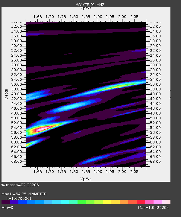
| Estimated Moho Depth: |
54.25 km |
| Estimated Crust Vp/Vs: |
1.67 |
| Assumed Crust Vp: |
6.35 km/s |
| Estimated Crust Vs: |
3.802 km/s |
| Estimated Crust Poisson's Ratio: |
0.22 |
|
| Radial Match: |
87.33286 % |
| Radial Bump: |
400 |
| Transverse Match: |
66.39109 % |
| Transverse Bump: |
400 |
| SOD ConfigId: |
2825771 |
| Insert Time: |
2018-09-21 02:35:28.985 +0000 |
| GWidth: |
2.5 |
| Max Bumps: |
400 |
| Tol: |
0.001 |
|

Signal To Noise
| Channel | StoN | STA | LTA |
| WY:YTP:01:HHZ:20180907T02:20:50.578027Z | 21.879862 | 9.392961E-8 | 4.2929704E-9 |
| WY:YTP:01:HHN:20180907T02:20:50.578027Z | 10.938877 | 4.7162747E-8 | 4.3114796E-9 |
| WY:YTP:01:HHE:20180907T02:20:50.578027Z | 12.318792 | 5.6823513E-8 | 4.61275E-9 |
| Arrivals |
| Ps | 6.0 SECOND |
| PpPs | 22 SECOND |
| PsPs/PpSs | 28 SECOND |


