You are here: Home > Network List > MB - Montana Regional Seismic Network Stations List
> Station SRMT Salmond Ranch > Earthquake Result Viewer
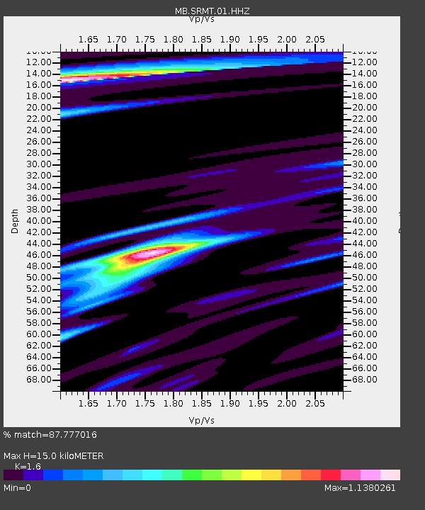
SRMT Salmond Ranch - Earthquake Result Viewer
| Earthquake location: |
Komandorskiye Ostrova Region |
| Earthquake latitude/longitude: |
55.5/166.3 |
| Earthquake time(UTC): |
2022/09/20 (263) 18:23:42 GMT |
| Earthquake Depth: |
10 km |
| Earthquake Magnitude: |
6.0 mww |
| Earthquake Catalog/Contributor: |
NEIC PDE/us |
|
| Network: |
MB Montana Regional Seismic Network |
| Station: |
SRMT Salmond Ranch |
| Lat/Lon: |
47.78 N/112.61 W |
| Elevation: |
1522 m |
|
| Distance: |
48.2 deg |
| Az: |
63.416 deg |
| Baz: |
311.083 deg |
| Ray Param: |
0.06954372 |
| Estimated Moho Depth: |
15.0 km |
| Estimated Crust Vp/Vs: |
1.60 |
| Assumed Crust Vp: |
6.353 km/s |
| Estimated Crust Vs: |
3.971 km/s |
| Estimated Crust Poisson's Ratio: |
0.18 |
|
| Radial Match: |
87.777016 % |
| Radial Bump: |
369 |
| Transverse Match: |
54.289654 % |
| Transverse Bump: |
400 |
| SOD ConfigId: |
28764291 |
| Insert Time: |
2022-10-04 18:42:13.538 +0000 |
| GWidth: |
2.5 |
| Max Bumps: |
400 |
| Tol: |
0.001 |
|

Signal To Noise
| Channel | StoN | STA | LTA |
| MB:SRMT:01:HHZ:20220920T18:31:52.280013Z | 7.9945445 | 9.84044E-7 | 1.2308944E-7 |
| MB:SRMT:01:HHN:20220920T18:31:52.280013Z | 2.7348073 | 3.1212798E-7 | 1.1413162E-7 |
| MB:SRMT:01:HHE:20220920T18:31:52.280013Z | 6.6213546 | 4.3334492E-7 | 6.5446564E-8 |
| Arrivals |
| Ps | 1.5 SECOND |
| PpPs | 5.7 SECOND |
| PsPs/PpSs | 7.3 SECOND |


