You are here: Home > Network List > N4 - Central and EAstern US Network Stations List
> Station W50A Signal Mountain, TN, USA > Earthquake Result Viewer
W50A Signal Mountain, TN, USA - Earthquake Result Viewer
| Earthquake location: |
Komandorskiye Ostrova Region |
| Earthquake latitude/longitude: |
55.5/166.3 |
| Earthquake time(UTC): |
2022/09/20 (263) 18:23:42 GMT |
| Earthquake Depth: |
10 km |
| Earthquake Magnitude: |
6.0 mww |
| Earthquake Catalog/Contributor: |
NEIC PDE/us |
|
| Network: |
N4 Central and EAstern US Network |
| Station: |
W50A Signal Mountain, TN, USA |
| Lat/Lon: |
35.20 N/85.31 W |
| Elevation: |
587 m |
|
| Distance: |
71.0 deg |
| Az: |
55.295 deg |
| Baz: |
325.2 deg |
| Ray Param: |
0.054612596 |
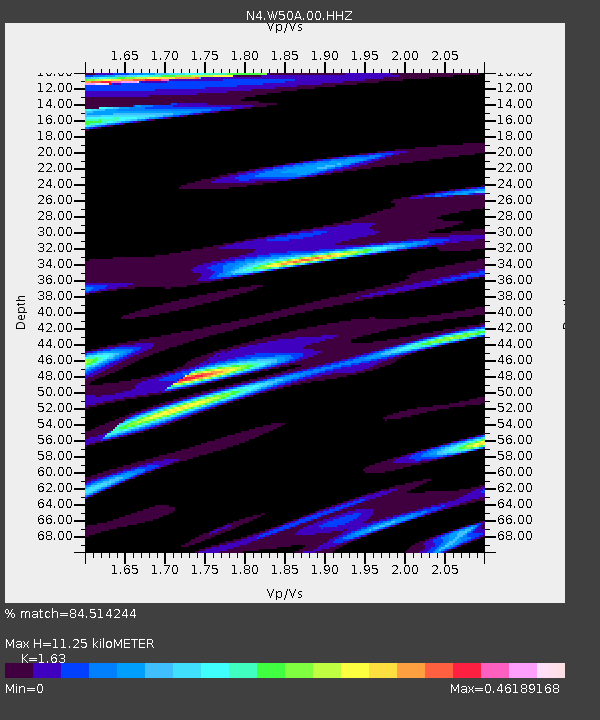
| Estimated Moho Depth: |
11.25 km |
| Estimated Crust Vp/Vs: |
1.63 |
| Assumed Crust Vp: |
6.35 km/s |
| Estimated Crust Vs: |
3.896 km/s |
| Estimated Crust Poisson's Ratio: |
0.20 |
|
| Radial Match: |
84.514244 % |
| Radial Bump: |
367 |
| Transverse Match: |
53.25963 % |
| Transverse Bump: |
400 |
| SOD ConfigId: |
28764291 |
| Insert Time: |
2022-10-04 18:45:01.283 +0000 |
| GWidth: |
2.5 |
| Max Bumps: |
400 |
| Tol: |
0.001 |
|

Signal To Noise
| Channel | StoN | STA | LTA |
| N4:W50A:00:HHZ:20220920T18:34:29.470016Z | 7.3334293 | 6.9704515E-7 | 9.505037E-8 |
| N4:W50A:00:HH1:20220920T18:34:29.470016Z | 1.8194575 | 1.5702392E-7 | 8.6302606E-8 |
| N4:W50A:00:HH2:20220920T18:34:29.470016Z | 1.2818733 | 1.3849717E-7 | 1.0804279E-7 |
| Arrivals |
| Ps | 1.2 SECOND |
| PpPs | 4.5 SECOND |
| PsPs/PpSs | 5.6 SECOND |


