You are here: Home > Network List > TD - TransAlta Monitoring Network Stations List
> Station TD008 Z > Earthquake Result Viewer
TD008 Z - Earthquake Result Viewer
| Earthquake location: |
Komandorskiye Ostrova Region |
| Earthquake latitude/longitude: |
55.5/166.3 |
| Earthquake time(UTC): |
2022/09/20 (263) 18:23:42 GMT |
| Earthquake Depth: |
10 km |
| Earthquake Magnitude: |
6.0 mww |
| Earthquake Catalog/Contributor: |
NEIC PDE/us |
|
| Network: |
TD TransAlta Monitoring Network |
| Station: |
TD008 Z |
| Lat/Lon: |
52.80 N/115.43 W |
| Elevation: |
964 m |
|
| Distance: |
43.6 deg |
| Az: |
59.516 deg |
| Baz: |
306.196 deg |
| Ray Param: |
0.072446436 |
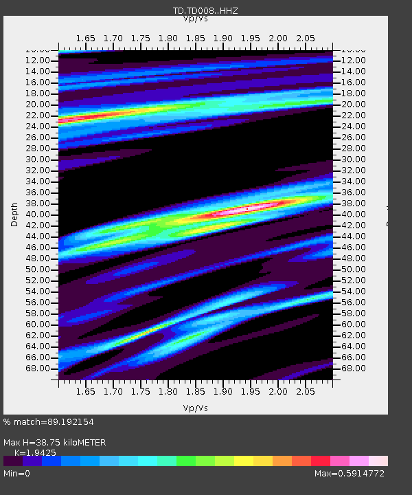
| Estimated Moho Depth: |
38.75 km |
| Estimated Crust Vp/Vs: |
1.94 |
| Assumed Crust Vp: |
6.426 km/s |
| Estimated Crust Vs: |
3.308 km/s |
| Estimated Crust Poisson's Ratio: |
0.32 |
|
| Radial Match: |
89.192154 % |
| Radial Bump: |
331 |
| Transverse Match: |
76.478836 % |
| Transverse Bump: |
397 |
| SOD ConfigId: |
28764291 |
| Insert Time: |
2022-10-04 18:54:15.735 +0000 |
| GWidth: |
2.5 |
| Max Bumps: |
400 |
| Tol: |
0.001 |
|

Signal To Noise
| Channel | StoN | STA | LTA |
| TD:TD008: :HHZ:20220920T18:31:16.340011Z | 7.9103627 | 1.2278955E-6 | 1.5522619E-7 |
| TD:TD008: :HH1:20220920T18:31:16.340011Z | 1.9173142 | 3.0569802E-7 | 1.5944076E-7 |
| TD:TD008: :HH2:20220920T18:31:16.340011Z | 5.323738 | 5.808803E-7 | 1.0911136E-7 |
| Arrivals |
| Ps | 6.0 SECOND |
| PpPs | 17 SECOND |
| PsPs/PpSs | 23 SECOND |


