You are here: Home > Network List > TD - TransAlta Monitoring Network Stations List
> Station TD007 Z > Earthquake Result Viewer
TD007 Z - Earthquake Result Viewer
| Earthquake location: |
Komandorskiye Ostrova Region |
| Earthquake latitude/longitude: |
55.5/166.3 |
| Earthquake time(UTC): |
2022/09/20 (263) 18:23:42 GMT |
| Earthquake Depth: |
10 km |
| Earthquake Magnitude: |
6.0 mww |
| Earthquake Catalog/Contributor: |
NEIC PDE/us |
|
| Network: |
TD TransAlta Monitoring Network |
| Station: |
TD007 Z |
| Lat/Lon: |
52.91 N/115.62 W |
| Elevation: |
988 m |
|
| Distance: |
43.5 deg |
| Az: |
59.491 deg |
| Baz: |
306.031 deg |
| Ray Param: |
0.07254368 |
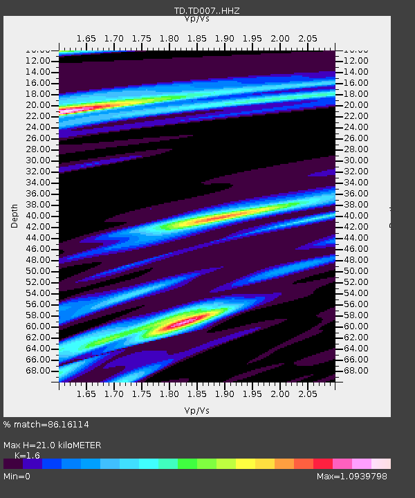
| Estimated Moho Depth: |
21.0 km |
| Estimated Crust Vp/Vs: |
1.60 |
| Assumed Crust Vp: |
6.426 km/s |
| Estimated Crust Vs: |
4.016 km/s |
| Estimated Crust Poisson's Ratio: |
0.18 |
|
| Radial Match: |
86.16114 % |
| Radial Bump: |
400 |
| Transverse Match: |
69.02315 % |
| Transverse Bump: |
349 |
| SOD ConfigId: |
28764291 |
| Insert Time: |
2022-10-04 18:54:16.049 +0000 |
| GWidth: |
2.5 |
| Max Bumps: |
400 |
| Tol: |
0.001 |
|

Signal To Noise
| Channel | StoN | STA | LTA |
| TD:TD007: :HHZ:20220920T18:31:15.12001Z | 5.371708 | 1.1525929E-6 | 2.145673E-7 |
| TD:TD007: :HH1:20220920T18:31:15.12001Z | 2.5447197 | 3.3480157E-7 | 1.3156718E-7 |
| TD:TD007: :HH2:20220920T18:31:15.12001Z | 2.2509925 | 3.5729227E-7 | 1.5872655E-7 |
| Arrivals |
| Ps | 2.1 SECOND |
| PpPs | 7.9 SECOND |
| PsPs/PpSs | 10 SECOND |


