You are here: Home > Network List > TX - Texas Seismological Network Stations List
> Station PLPT Palo Pinto > Earthquake Result Viewer
PLPT Palo Pinto - Earthquake Result Viewer
| Earthquake location: |
Komandorskiye Ostrova Region |
| Earthquake latitude/longitude: |
55.5/166.3 |
| Earthquake time(UTC): |
2022/09/20 (263) 18:23:42 GMT |
| Earthquake Depth: |
10 km |
| Earthquake Magnitude: |
6.0 mww |
| Earthquake Catalog/Contributor: |
NEIC PDE/us |
|
| Network: |
TX Texas Seismological Network |
| Station: |
PLPT Palo Pinto |
| Lat/Lon: |
32.81 N/98.32 W |
| Elevation: |
336 m |
|
| Distance: |
66.5 deg |
| Az: |
66.122 deg |
| Baz: |
321.877 deg |
| Ray Param: |
0.057590008 |
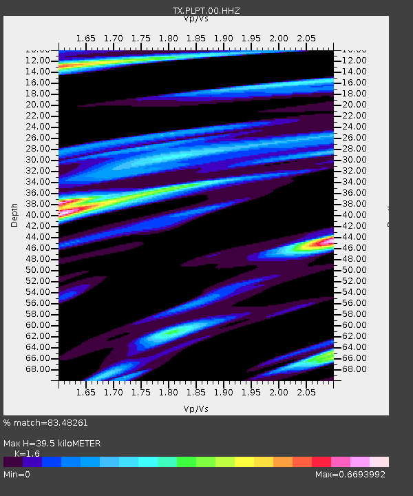
| Estimated Moho Depth: |
39.5 km |
| Estimated Crust Vp/Vs: |
1.60 |
| Assumed Crust Vp: |
6.426 km/s |
| Estimated Crust Vs: |
4.016 km/s |
| Estimated Crust Poisson's Ratio: |
0.18 |
|
| Radial Match: |
83.48261 % |
| Radial Bump: |
359 |
| Transverse Match: |
53.481125 % |
| Transverse Bump: |
358 |
| SOD ConfigId: |
28764291 |
| Insert Time: |
2022-10-04 18:55:40.880 +0000 |
| GWidth: |
2.5 |
| Max Bumps: |
400 |
| Tol: |
0.001 |
|

Signal To Noise
| Channel | StoN | STA | LTA |
| TX:PLPT:00:HHZ:20220920T18:34:01.340011Z | 7.6314745 | 6.582744E-7 | 8.625783E-8 |
| TX:PLPT:00:HH1:20220920T18:34:01.340011Z | 1.6460253 | 1.704584E-7 | 1.0355759E-7 |
| TX:PLPT:00:HH2:20220920T18:34:01.340011Z | 3.0774636 | 3.6259976E-7 | 1.17824214E-7 |
| Arrivals |
| Ps | 3.9 SECOND |
| PpPs | 15 SECOND |
| PsPs/PpSs | 19 SECOND |


