You are here: Home > Network List > US - United States National Seismic Network Stations List
> Station OGNE Ogallala, Nebraska, USA > Earthquake Result Viewer
OGNE Ogallala, Nebraska, USA - Earthquake Result Viewer
| Earthquake location: |
Komandorskiye Ostrova Region |
| Earthquake latitude/longitude: |
55.5/166.3 |
| Earthquake time(UTC): |
2022/09/20 (263) 18:23:42 GMT |
| Earthquake Depth: |
10 km |
| Earthquake Magnitude: |
6.0 mww |
| Earthquake Catalog/Contributor: |
NEIC PDE/us |
|
| Network: |
US United States National Seismic Network |
| Station: |
OGNE Ogallala, Nebraska, USA |
| Lat/Lon: |
40.95 N/102.03 W |
| Elevation: |
1054 m |
|
| Distance: |
58.3 deg |
| Az: |
62.818 deg |
| Baz: |
318.115 deg |
| Ray Param: |
0.06290208 |
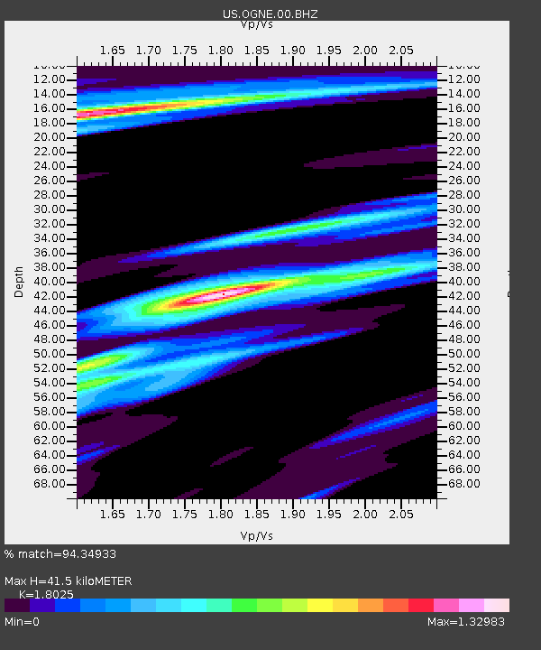
| Estimated Moho Depth: |
41.5 km |
| Estimated Crust Vp/Vs: |
1.80 |
| Assumed Crust Vp: |
6.483 km/s |
| Estimated Crust Vs: |
3.596 km/s |
| Estimated Crust Poisson's Ratio: |
0.28 |
|
| Radial Match: |
94.34933 % |
| Radial Bump: |
300 |
| Transverse Match: |
76.57314 % |
| Transverse Bump: |
355 |
| SOD ConfigId: |
28764291 |
| Insert Time: |
2022-10-04 18:58:08.909 +0000 |
| GWidth: |
2.5 |
| Max Bumps: |
400 |
| Tol: |
0.001 |
|

Signal To Noise
| Channel | StoN | STA | LTA |
| US:OGNE:00:BHZ:20220920T18:33:07.023971Z | 8.14762 | 9.4792756E-7 | 1.16344104E-7 |
| US:OGNE:00:BH1:20220920T18:33:07.023971Z | 1.8942772 | 3.4108885E-7 | 1.800628E-7 |
| US:OGNE:00:BH2:20220920T18:33:07.023971Z | 2.9400978 | 5.5825626E-7 | 1.8987677E-7 |
| Arrivals |
| Ps | 5.4 SECOND |
| PpPs | 17 SECOND |
| PsPs/PpSs | 22 SECOND |


