You are here: Home > Network List > US - United States National Seismic Network Stations List
> Station WMOK Wichita Mountains, Oklahoma, USA > Earthquake Result Viewer
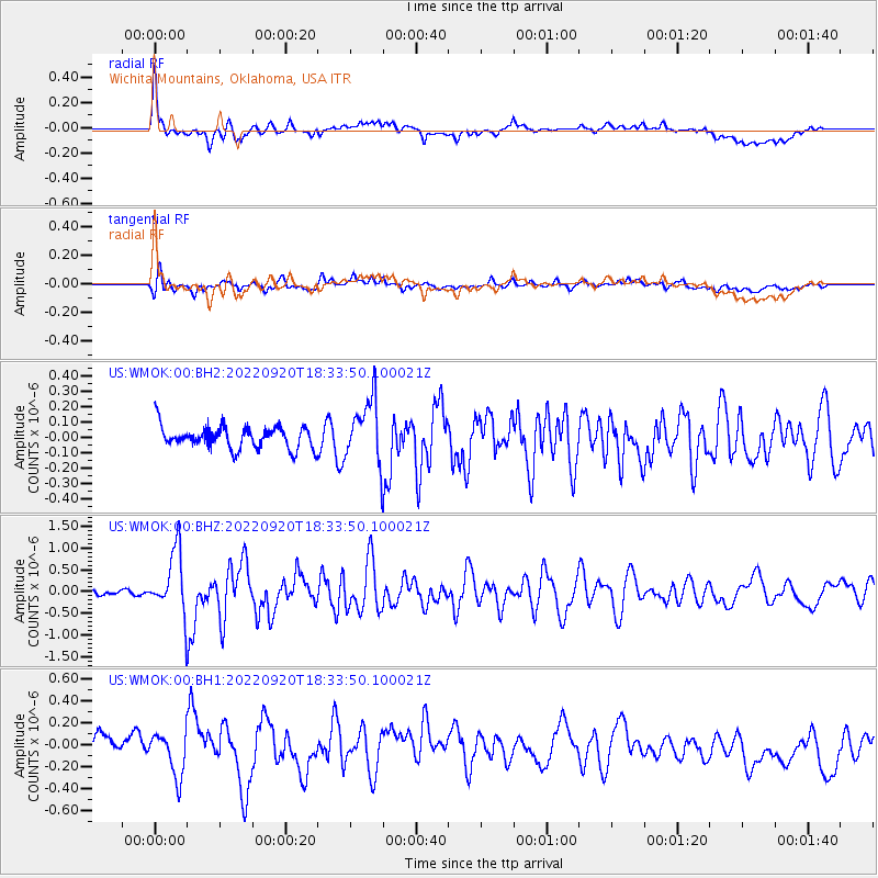
WMOK Wichita Mountains, Oklahoma, USA - Earthquake Result Viewer
*The percent match for this event was below the threshold and hence no stack was calculated.
| Earthquake location: |
Komandorskiye Ostrova Region |
| Earthquake latitude/longitude: |
55.5/166.3 |
| Earthquake time(UTC): |
2022/09/20 (263) 18:23:42 GMT |
| Earthquake Depth: |
10 km |
| Earthquake Magnitude: |
6.0 mww |
| Earthquake Catalog/Contributor: |
NEIC PDE/us |
|
| Network: |
US United States National Seismic Network |
| Station: |
WMOK Wichita Mountains, Oklahoma, USA |
| Lat/Lon: |
34.74 N/98.78 W |
| Elevation: |
486 m |
|
| Distance: |
64.7 deg |
| Az: |
65.144 deg |
| Baz: |
321.216 deg |
| Ray Param: |
$rayparam |
*The percent match for this event was below the threshold and hence was not used in the summary stack. |
|
| Radial Match: |
72.829025 % |
| Radial Bump: |
400 |
| Transverse Match: |
65.64697 % |
| Transverse Bump: |
400 |
| SOD ConfigId: |
28764291 |
| Insert Time: |
2022-10-04 18:58:18.761 +0000 |
| GWidth: |
2.5 |
| Max Bumps: |
400 |
| Tol: |
0.001 |
|
Signal To Noise
| Channel | StoN | STA | LTA |
| US:WMOK:00:BHZ:20220920T18:33:50.100021Z | 11.531151 | 7.082422E-7 | 6.1419904E-8 |
| US:WMOK:00:BH1:20220920T18:33:50.100021Z | 1.4847183 | 1.8939743E-7 | 1.2756455E-7 |
| US:WMOK:00:BH2:20220920T18:33:50.100021Z | 2.8464901 | 2.0444004E-7 | 7.1821795E-8 |
| Arrivals |
| Ps | |
| PpPs | |
| PsPs/PpSs | |


