You are here: Home > Network List > XL17 - McGill Dawson-Septimus Induced Seismicity Study () Stations List
> Station MG04 Z > Earthquake Result Viewer
MG04 Z - Earthquake Result Viewer
| Earthquake location: |
Komandorskiye Ostrova Region |
| Earthquake latitude/longitude: |
55.5/166.3 |
| Earthquake time(UTC): |
2022/09/20 (263) 18:23:42 GMT |
| Earthquake Depth: |
10 km |
| Earthquake Magnitude: |
6.0 mww |
| Earthquake Catalog/Contributor: |
NEIC PDE/us |
|
| Network: |
XL McGill Dawson-Septimus Induced Seismicity Study () |
| Station: |
MG04 Z |
| Lat/Lon: |
55.99 N/120.34 W |
| Elevation: |
682 m |
|
| Distance: |
39.4 deg |
| Az: |
57.902 deg |
| Baz: |
301.004 deg |
| Ray Param: |
0.07498811 |
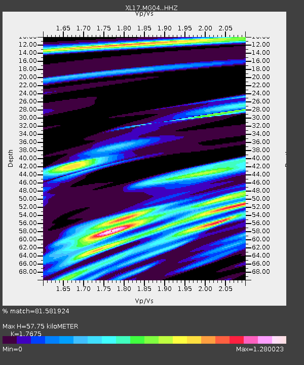
| Estimated Moho Depth: |
57.75 km |
| Estimated Crust Vp/Vs: |
1.77 |
| Assumed Crust Vp: |
6.303 km/s |
| Estimated Crust Vs: |
3.566 km/s |
| Estimated Crust Poisson's Ratio: |
0.26 |
|
| Radial Match: |
81.581924 % |
| Radial Bump: |
352 |
| Transverse Match: |
67.02894 % |
| Transverse Bump: |
400 |
| SOD ConfigId: |
28764291 |
| Insert Time: |
2022-10-04 19:03:36.519 +0000 |
| GWidth: |
2.5 |
| Max Bumps: |
400 |
| Tol: |
0.001 |
|

Signal To Noise
| Channel | StoN | STA | LTA |
| XL:MG04: :HHZ:20220920T18:30:42.310012Z | 2.9474356 | 8.0794706E-7 | 2.7411863E-7 |
| XL:MG04: :HHN:20220920T18:30:42.310012Z | 0.9044327 | 5.916599E-7 | 6.541779E-7 |
| XL:MG04: :HHE:20220920T18:30:42.310012Z | 0.7873102 | 3.5826426E-7 | 4.550484E-7 |
| Arrivals |
| Ps | 7.5 SECOND |
| PpPs | 24 SECOND |
| PsPs/PpSs | 31 SECOND |


