You are here: Home > Network List > WW - Idaho Seismic Network () Stations List
> Station TYLR Tyler Ranch Idaho > Earthquake Result Viewer
TYLR Tyler Ranch Idaho - Earthquake Result Viewer
| Earthquake location: |
Komandorskiye Ostrova Region |
| Earthquake latitude/longitude: |
55.5/166.3 |
| Earthquake time(UTC): |
2022/09/20 (263) 18:23:42 GMT |
| Earthquake Depth: |
10 km |
| Earthquake Magnitude: |
6.0 mww |
| Earthquake Catalog/Contributor: |
NEIC PDE/us |
|
| Network: |
WW Idaho Seismic Network () |
| Station: |
TYLR Tyler Ranch Idaho |
| Lat/Lon: |
45.10 N/114.85 W |
| Elevation: |
1203 m |
|
| Distance: |
48.8 deg |
| Az: |
67.463 deg |
| Baz: |
312.145 deg |
| Ray Param: |
0.069140024 |
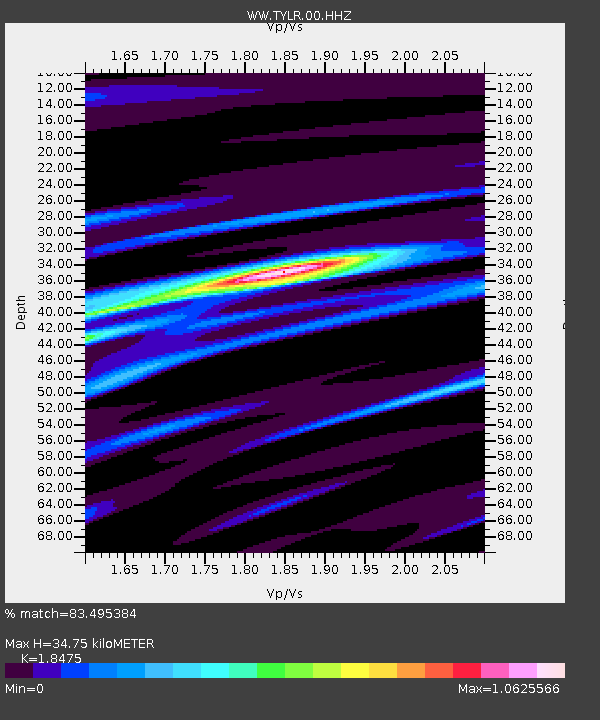
| Estimated Moho Depth: |
34.75 km |
| Estimated Crust Vp/Vs: |
1.85 |
| Assumed Crust Vp: |
6.577 km/s |
| Estimated Crust Vs: |
3.56 km/s |
| Estimated Crust Poisson's Ratio: |
0.29 |
|
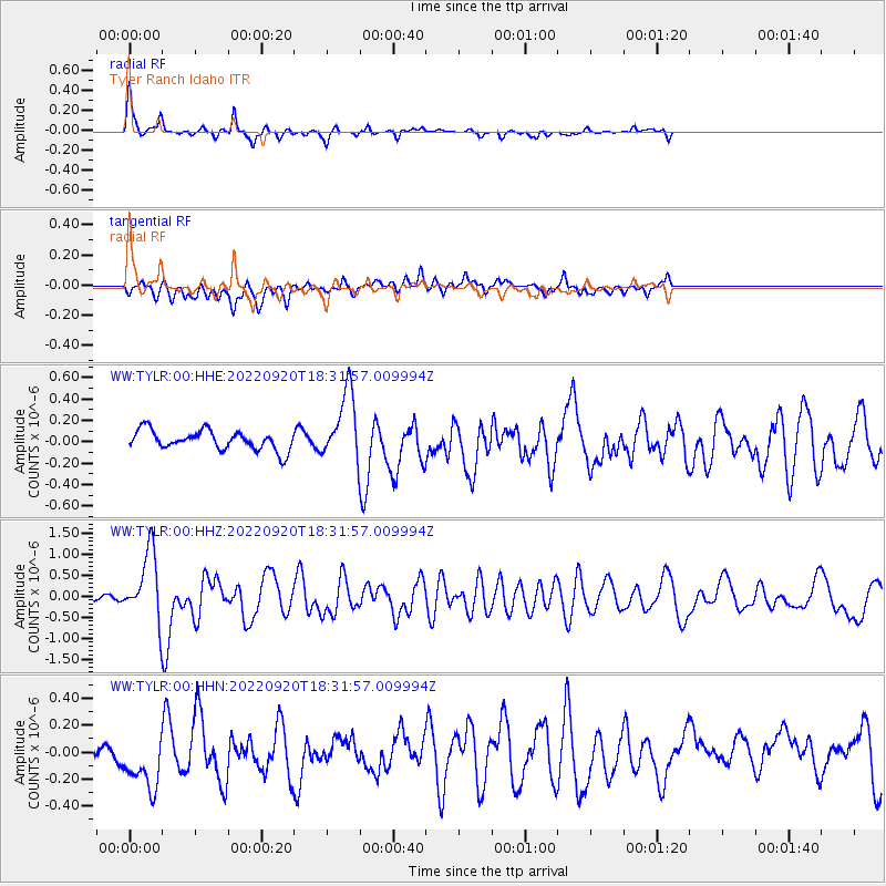
| Radial Match: |
83.495384 % |
| Radial Bump: |
278 |
| Transverse Match: |
76.30051 % |
| Transverse Bump: |
400 |
| SOD ConfigId: |
28764291 |
| Insert Time: |
2022-10-04 19:04:22.336 +0000 |
| GWidth: |
2.5 |
| Max Bumps: |
400 |
| Tol: |
0.001 |
|
Signal To Noise
| Channel | StoN | STA | LTA |
| WW:TYLR:00:HHZ:20220920T18:31:57.009994Z | 6.6135964 | 8.005633E-7 | 1.210481E-7 |
| WW:TYLR:00:HHN:20220920T18:31:57.009994Z | 2.9386625 | 2.429563E-7 | 8.267581E-8 |
| WW:TYLR:00:HHE:20220920T18:31:57.009994Z | 3.5269399 | 3.1971686E-7 | 9.0649934E-8 |
| Arrivals |
| Ps | 4.8 SECOND |
| PpPs | 14 SECOND |
| PsPs/PpSs | 19 SECOND |


