You are here: Home > Network List > TX - Texas Seismological Network Stations List
> Station WTFS Witchita Falls > Earthquake Result Viewer
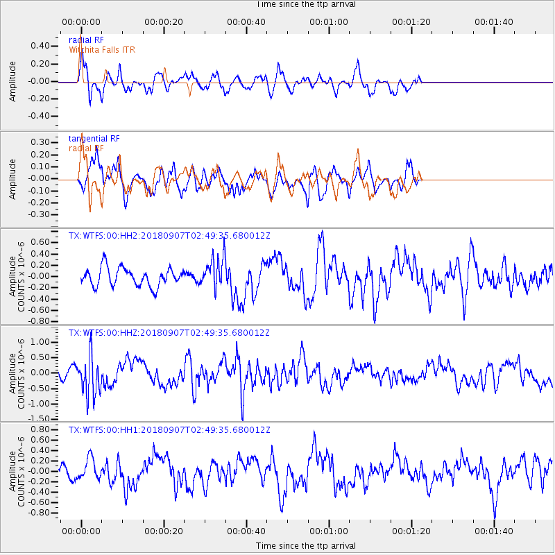
WTFS Witchita Falls - Earthquake Result Viewer
*The percent match for this event was below the threshold and hence no stack was calculated.
| Earthquake location: |
Chile-Argentina Border Region |
| Earthquake latitude/longitude: |
-28.9/-70.0 |
| Earthquake time(UTC): |
2018/09/07 (250) 02:39:17 GMT |
| Earthquake Depth: |
92 km |
| Earthquake Magnitude: |
5.8 Mww |
| Earthquake Catalog/Contributor: |
NEIC PDE/us |
|
| Network: |
TX Texas Seismological Network |
| Station: |
WTFS Witchita Falls |
| Lat/Lon: |
33.77 N/98.46 W |
| Elevation: |
277 m |
|
| Distance: |
67.9 deg |
| Az: |
334.589 deg |
| Baz: |
153.147 deg |
| Ray Param: |
$rayparam |
*The percent match for this event was below the threshold and hence was not used in the summary stack. |
|
| Radial Match: |
59.968124 % |
| Radial Bump: |
321 |
| Transverse Match: |
73.86826 % |
| Transverse Bump: |
342 |
| SOD ConfigId: |
2825771 |
| Insert Time: |
2018-09-21 02:45:01.300 +0000 |
| GWidth: |
2.5 |
| Max Bumps: |
400 |
| Tol: |
0.001 |
|
Signal To Noise
| Channel | StoN | STA | LTA |
| TX:WTFS:00:HHZ:20180907T02:49:35.680012Z | 5.517898 | 6.350785E-7 | 1.15094274E-7 |
| TX:WTFS:00:HH1:20180907T02:49:35.680012Z | 1.1156303 | 2.0944353E-7 | 1.8773562E-7 |
| TX:WTFS:00:HH2:20180907T02:49:35.680012Z | 1.7120025 | 2.761602E-7 | 1.613083E-7 |
| Arrivals |
| Ps | |
| PpPs | |
| PsPs/PpSs | |


