You are here: Home > Network List > AK - Alaska Regional Network Stations List
> Station B20K Meade River, AK, USA > Earthquake Result Viewer
B20K Meade River, AK, USA - Earthquake Result Viewer
| Earthquake location: |
Michoacan, Mexico |
| Earthquake latitude/longitude: |
18.4/-102.9 |
| Earthquake time(UTC): |
2022/09/22 (265) 06:16:11 GMT |
| Earthquake Depth: |
61 km |
| Earthquake Magnitude: |
6.8 mww |
| Earthquake Catalog/Contributor: |
NEIC PDE/at |
|
| Network: |
AK Alaska Regional Network |
| Station: |
B20K Meade River, AK, USA |
| Lat/Lon: |
70.01 N/157.16 W |
| Elevation: |
75 m |
|
| Distance: |
61.0 deg |
| Az: |
341.381 deg |
| Baz: |
118.179 deg |
| Ray Param: |
0.061039723 |
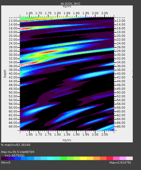
| Estimated Moho Depth: |
35.5 km |
| Estimated Crust Vp/Vs: |
1.61 |
| Assumed Crust Vp: |
6.048 km/s |
| Estimated Crust Vs: |
3.762 km/s |
| Estimated Crust Poisson's Ratio: |
0.18 |
|
| Radial Match: |
92.39348 % |
| Radial Bump: |
335 |
| Transverse Match: |
82.81018 % |
| Transverse Bump: |
400 |
| SOD ConfigId: |
28764291 |
| Insert Time: |
2022-10-06 06:18:15.107 +0000 |
| GWidth: |
2.5 |
| Max Bumps: |
400 |
| Tol: |
0.001 |
|

Signal To Noise
| Channel | StoN | STA | LTA |
| AK:B20K: :BHZ:20220922T06:25:47.140015Z | 5.335278 | 1.0679978E-6 | 2.001766E-7 |
| AK:B20K: :BHN:20220922T06:25:47.140015Z | 0.6181078 | 1.4990523E-7 | 2.425228E-7 |
| AK:B20K: :BHE:20220922T06:25:47.140015Z | 2.0937622 | 4.0320086E-7 | 1.9257243E-7 |
| Arrivals |
| Ps | 3.7 SECOND |
| PpPs | 15 SECOND |
| PsPs/PpSs | 18 SECOND |


