You are here: Home > Network List > AK - Alaska Regional Network Stations List
> Station K13K Kusilvak Mountain, AK, USA > Earthquake Result Viewer
K13K Kusilvak Mountain, AK, USA - Earthquake Result Viewer
| Earthquake location: |
Michoacan, Mexico |
| Earthquake latitude/longitude: |
18.4/-102.9 |
| Earthquake time(UTC): |
2022/09/22 (265) 06:16:11 GMT |
| Earthquake Depth: |
61 km |
| Earthquake Magnitude: |
6.8 mww |
| Earthquake Catalog/Contributor: |
NEIC PDE/at |
|
| Network: |
AK Alaska Regional Network |
| Station: |
K13K Kusilvak Mountain, AK, USA |
| Lat/Lon: |
61.93 N/164.66 W |
| Elevation: |
204 m |
|
| Distance: |
60.7 deg |
| Az: |
331.468 deg |
| Baz: |
106.484 deg |
| Ray Param: |
0.061201047 |
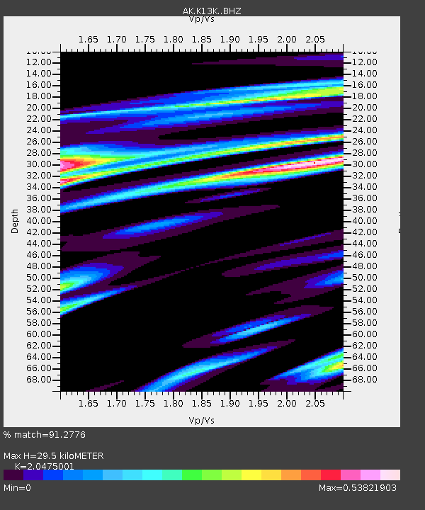
| Estimated Moho Depth: |
29.5 km |
| Estimated Crust Vp/Vs: |
2.05 |
| Assumed Crust Vp: |
6.1 km/s |
| Estimated Crust Vs: |
2.979 km/s |
| Estimated Crust Poisson's Ratio: |
0.34 |
|
| Radial Match: |
91.2776 % |
| Radial Bump: |
373 |
| Transverse Match: |
79.11866 % |
| Transverse Bump: |
400 |
| SOD ConfigId: |
28764291 |
| Insert Time: |
2022-10-06 06:19:50.187 +0000 |
| GWidth: |
2.5 |
| Max Bumps: |
400 |
| Tol: |
0.001 |
|

Signal To Noise
| Channel | StoN | STA | LTA |
| AK:K13K: :BHZ:20220922T06:25:45.539978Z | 8.0105915 | 1.6041542E-6 | 2.0025416E-7 |
| AK:K13K: :BHN:20220922T06:25:45.539978Z | 1.3979656 | 2.9636968E-7 | 2.120007E-7 |
| AK:K13K: :BHE:20220922T06:25:45.539978Z | 3.3970466 | 7.295725E-7 | 2.147667E-7 |
| Arrivals |
| Ps | 5.2 SECOND |
| PpPs | 14 SECOND |
| PsPs/PpSs | 19 SECOND |


