You are here: Home > Network List > XA95 - Missouri to Massachusetts Transect Stations List
> Station MM04 LeRaysville, Pennsylvania > Earthquake Result Viewer
MM04 LeRaysville, Pennsylvania - Earthquake Result Viewer
| Earthquake location: |
Baja California, Mexico |
| Earthquake latitude/longitude: |
24.6/-110.3 |
| Earthquake time(UTC): |
1995/06/30 (181) 11:58:56 GMT |
| Earthquake Depth: |
10 km |
| Earthquake Magnitude: |
5.8 MB, 6.3 MS, 6.2 UNKNOWN |
| Earthquake Catalog/Contributor: |
WHDF/NEIC |
|
| Network: |
XA Missouri to Massachusetts Transect |
| Station: |
MM04 LeRaysville, Pennsylvania |
| Lat/Lon: |
41.85 N/76.20 W |
| Elevation: |
473 m |
|
| Distance: |
33.0 deg |
| Az: |
50.205 deg |
| Baz: |
249.397 deg |
| Ray Param: |
0.07840968 |
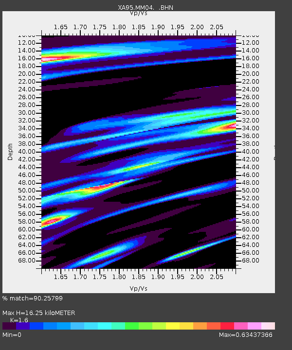
| Estimated Moho Depth: |
16.25 km |
| Estimated Crust Vp/Vs: |
1.60 |
| Assumed Crust Vp: |
6.121 km/s |
| Estimated Crust Vs: |
3.825 km/s |
| Estimated Crust Poisson's Ratio: |
0.18 |
|
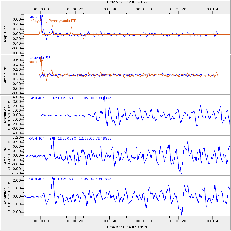
| Radial Match: |
90.25799 % |
| Radial Bump: |
336 |
| Transverse Match: |
70.03937 % |
| Transverse Bump: |
400 |
| SOD ConfigId: |
6273 |
| Insert Time: |
2010-02-26 17:44:53.519 +0000 |
| GWidth: |
2.5 |
| Max Bumps: |
400 |
| Tol: |
0.001 |
|
Signal To Noise
| Channel | StoN | STA | LTA |
| XA:MM04: :BHN:19950630T12:05:00.794989Z | 1.8481311 | 1.1033469E-7 | 5.970068E-8 |
| XA:MM04: :BHE:19950630T12:05:00.794989Z | 5.2391815 | 4.0972654E-7 | 7.82043E-8 |
| XA:MM04: :BHZ:19950630T12:05:00.794989Z | 6.0248976 | 6.137205E-7 | 1.0186405E-7 |
| Arrivals |
| Ps | 1.7 SECOND |
| PpPs | 6.4 SECOND |
| PsPs/PpSs | 8.1 SECOND |


