You are here: Home > Network List > CC - Cascade Chain Volcano Monitoring Stations List
> Station PR01 Puyallup River 01 > Earthquake Result Viewer
PR01 Puyallup River 01 - Earthquake Result Viewer
| Earthquake location: |
Michoacan, Mexico |
| Earthquake latitude/longitude: |
18.4/-102.9 |
| Earthquake time(UTC): |
2022/09/22 (265) 06:16:11 GMT |
| Earthquake Depth: |
61 km |
| Earthquake Magnitude: |
6.8 mww |
| Earthquake Catalog/Contributor: |
NEIC PDE/at |
|
| Network: |
CC Cascade Chain Volcano Monitoring |
| Station: |
PR01 Puyallup River 01 |
| Lat/Lon: |
46.91 N/122.04 W |
| Elevation: |
648 m |
|
| Distance: |
32.5 deg |
| Az: |
335.271 deg |
| Baz: |
144.594 deg |
| Ray Param: |
0.078492396 |
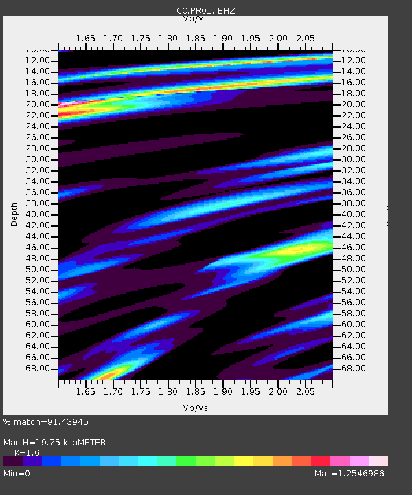
| Estimated Moho Depth: |
19.75 km |
| Estimated Crust Vp/Vs: |
1.60 |
| Assumed Crust Vp: |
6.566 km/s |
| Estimated Crust Vs: |
4.104 km/s |
| Estimated Crust Poisson's Ratio: |
0.18 |
|
| Radial Match: |
91.43945 % |
| Radial Bump: |
388 |
| Transverse Match: |
80.355835 % |
| Transverse Bump: |
400 |
| SOD ConfigId: |
28764291 |
| Insert Time: |
2022-10-06 06:24:57.664 +0000 |
| GWidth: |
2.5 |
| Max Bumps: |
400 |
| Tol: |
0.001 |
|

Signal To Noise
| Channel | StoN | STA | LTA |
| CC:PR01: :BHZ:20220922T06:22:05.600006Z | 20.261631 | 1.6216542E-6 | 8.003572E-8 |
| CC:PR01: :BHN:20220922T06:22:05.600006Z | 5.166719 | 5.268929E-7 | 1.0197824E-7 |
| CC:PR01: :BHE:20220922T06:22:05.600006Z | 2.3799658 | 2.1942088E-7 | 9.219497E-8 |
| Arrivals |
| Ps | 2.0 SECOND |
| PpPs | 7.1 SECOND |
| PsPs/PpSs | 9.1 SECOND |


