You are here: Home > Network List > XA95 - Missouri to Massachusetts Transect Stations List
> Station MM04 LeRaysville, Pennsylvania > Earthquake Result Viewer
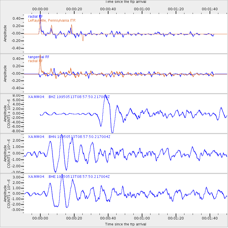
MM04 LeRaysville, Pennsylvania - Earthquake Result Viewer

| Earthquake location: |
Greece |
| Earthquake latitude/longitude: |
40.1/21.7 |
| Earthquake time(UTC): |
1995/05/13 (133) 08:47:12 GMT |
| Earthquake Depth: |
13 km |
| Earthquake Magnitude: |
6.2 MB, 6.5 MS, 6.6 UNKNOWN, 6.5 MD |
| Earthquake Catalog/Contributor: |
WHDF/NEIC |
|
| Network: |
XA Missouri to Massachusetts Transect |
| Station: |
MM04 LeRaysville, Pennsylvania |
| Lat/Lon: |
41.85 N/76.20 W |
| Elevation: |
473 m |
|
| Distance: |
69.6 deg |
| Az: |
307.864 deg |
| Baz: |
54.101 deg |
| Ray Param: |
0.055524454 |
| Estimated Moho Depth: |
43.5 km |
| Estimated Crust Vp/Vs: |
1.64 |
| Assumed Crust Vp: |
6.121 km/s |
| Estimated Crust Vs: |
3.738 km/s |
| Estimated Crust Poisson's Ratio: |
0.20 |
|
| Radial Match: |
94.0934 % |
| Radial Bump: |
325 |
| Transverse Match: |
82.68913 % |
| Transverse Bump: |
400 |
| SOD ConfigId: |
6273 |
| Insert Time: |
2010-02-26 17:44:57.885 +0000 |
| GWidth: |
2.5 |
| Max Bumps: |
400 |
| Tol: |
0.001 |
|
Signal To Noise
| Channel | StoN | STA | LTA |
| XA:MM04: :BHN:19950513T08:57:50.217004Z | 1.0426742 | 2.9497465E-7 | 2.8290205E-7 |
| XA:MM04: :BHE:19950513T08:57:50.217004Z | 1.392824 | 2.8489924E-7 | 2.045479E-7 |
| XA:MM04: :BHZ:19950513T08:57:50.217004Z | 2.5828907 | 8.189448E-7 | 3.170652E-7 |
| Arrivals |
| Ps | 4.7 SECOND |
| PpPs | 18 SECOND |
| PsPs/PpSs | 23 SECOND |


