You are here: Home > Network List > PR - Puerto Rico Seismic Network (PRSN) & Puerto Rico Strong Motion Program (PRSMP) Stations List
> Station CELP Cerrilos Dam > Earthquake Result Viewer
CELP Cerrilos Dam - Earthquake Result Viewer
| Earthquake location: |
Michoacan, Mexico |
| Earthquake latitude/longitude: |
18.4/-102.9 |
| Earthquake time(UTC): |
2022/09/22 (265) 06:16:11 GMT |
| Earthquake Depth: |
61 km |
| Earthquake Magnitude: |
6.8 mww |
| Earthquake Catalog/Contributor: |
NEIC PDE/at |
|
| Network: |
PR Puerto Rico Seismic Network (PRSN) & Puerto Rico Strong Motion Program (PRSMP) |
| Station: |
CELP Cerrilos Dam |
| Lat/Lon: |
18.07 N/66.58 W |
| Elevation: |
196 m |
|
| Distance: |
34.5 deg |
| Az: |
84.693 deg |
| Baz: |
276.345 deg |
| Ray Param: |
0.07757452 |
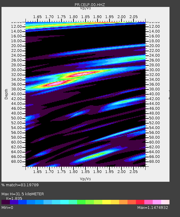
| Estimated Moho Depth: |
31.5 km |
| Estimated Crust Vp/Vs: |
1.84 |
| Assumed Crust Vp: |
5.14 km/s |
| Estimated Crust Vs: |
2.801 km/s |
| Estimated Crust Poisson's Ratio: |
0.29 |
|
| Radial Match: |
83.19789 % |
| Radial Bump: |
319 |
| Transverse Match: |
73.489876 % |
| Transverse Bump: |
400 |
| SOD ConfigId: |
28764291 |
| Insert Time: |
2022-10-06 06:33:51.746 +0000 |
| GWidth: |
2.5 |
| Max Bumps: |
400 |
| Tol: |
0.001 |
|

Signal To Noise
| Channel | StoN | STA | LTA |
| PR:CELP:00:HHZ:20220922T06:22:22.619995Z | 4.704575 | 1.8631254E-6 | 3.9602415E-7 |
| PR:CELP:00:HH1:20220922T06:22:22.619995Z | 0.6638993 | 3.0889152E-7 | 4.652686E-7 |
| PR:CELP:00:HH2:20220922T06:22:22.619995Z | 1.8459282 | 8.5785354E-7 | 4.647275E-7 |
| Arrivals |
| Ps | 5.4 SECOND |
| PpPs | 17 SECOND |
| PsPs/PpSs | 22 SECOND |


