You are here: Home > Network List > UW - Pacific Northwest Regional Seismic Network Stations List
> Station DOSE Dosewallips old TA.C04A, WA > Earthquake Result Viewer
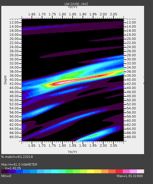
DOSE Dosewallips old TA.C04A, WA - Earthquake Result Viewer
| Earthquake location: |
Michoacan, Mexico |
| Earthquake latitude/longitude: |
18.4/-102.9 |
| Earthquake time(UTC): |
2022/09/22 (265) 06:16:11 GMT |
| Earthquake Depth: |
61 km |
| Earthquake Magnitude: |
6.8 mww |
| Earthquake Catalog/Contributor: |
NEIC PDE/at |
|
| Network: |
UW Pacific Northwest Regional Seismic Network |
| Station: |
DOSE Dosewallips old TA.C04A, WA |
| Lat/Lon: |
47.72 N/122.97 W |
| Elevation: |
53 m |
|
| Distance: |
33.5 deg |
| Az: |
335.191 deg |
| Baz: |
143.843 deg |
| Ray Param: |
0.0780355 |
| Estimated Moho Depth: |
41.0 km |
| Estimated Crust Vp/Vs: |
1.81 |
| Assumed Crust Vp: |
6.566 km/s |
| Estimated Crust Vs: |
3.623 km/s |
| Estimated Crust Poisson's Ratio: |
0.28 |
|
| Radial Match: |
93.22019 % |
| Radial Bump: |
363 |
| Transverse Match: |
64.80735 % |
| Transverse Bump: |
400 |
| SOD ConfigId: |
28764291 |
| Insert Time: |
2022-10-06 06:36:49.562 +0000 |
| GWidth: |
2.5 |
| Max Bumps: |
400 |
| Tol: |
0.001 |
|

Signal To Noise
| Channel | StoN | STA | LTA |
| UW:DOSE: :HHZ:20220922T06:22:14.529999Z | 27.598646 | 2.0754055E-6 | 7.519954E-8 |
| UW:DOSE: :HHN:20220922T06:22:14.529999Z | 15.895711 | 1.0578026E-6 | 6.654642E-8 |
| UW:DOSE: :HHE:20220922T06:22:14.529999Z | 9.403671 | 8.539837E-7 | 9.081386E-8 |
| Arrivals |
| Ps | 5.5 SECOND |
| PpPs | 16 SECOND |
| PsPs/PpSs | 22 SECOND |


