You are here: Home > Network List > UW - Pacific Northwest Regional Seismic Network Stations List
> Station DOTY Weyerhaeuser Tree Farm, Grays Harbor County, WA, USA > Earthquake Result Viewer
DOTY Weyerhaeuser Tree Farm, Grays Harbor County, WA, USA - Earthquake Result Viewer
| Earthquake location: |
Michoacan, Mexico |
| Earthquake latitude/longitude: |
18.4/-102.9 |
| Earthquake time(UTC): |
2022/09/22 (265) 06:16:11 GMT |
| Earthquake Depth: |
61 km |
| Earthquake Magnitude: |
6.8 mww |
| Earthquake Catalog/Contributor: |
NEIC PDE/at |
|
| Network: |
UW Pacific Northwest Regional Seismic Network |
| Station: |
DOTY Weyerhaeuser Tree Farm, Grays Harbor County, WA, USA |
| Lat/Lon: |
46.70 N/123.37 W |
| Elevation: |
430 m |
|
| Distance: |
32.9 deg |
| Az: |
333.684 deg |
| Baz: |
142.291 deg |
| Ray Param: |
0.07832302 |
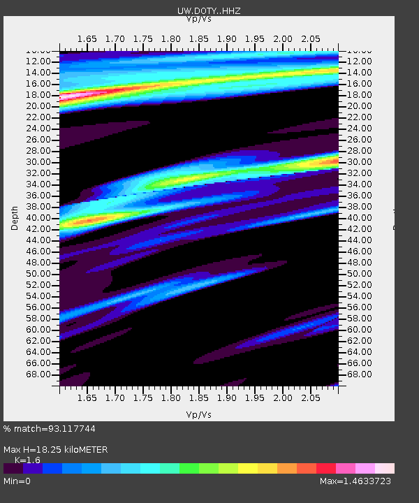
| Estimated Moho Depth: |
18.25 km |
| Estimated Crust Vp/Vs: |
1.60 |
| Assumed Crust Vp: |
6.566 km/s |
| Estimated Crust Vs: |
4.104 km/s |
| Estimated Crust Poisson's Ratio: |
0.18 |
|
| Radial Match: |
93.117744 % |
| Radial Bump: |
386 |
| Transverse Match: |
71.86122 % |
| Transverse Bump: |
400 |
| SOD ConfigId: |
28764291 |
| Insert Time: |
2022-10-06 06:36:51.535 +0000 |
| GWidth: |
2.5 |
| Max Bumps: |
400 |
| Tol: |
0.001 |
|

Signal To Noise
| Channel | StoN | STA | LTA |
| UW:DOTY: :HHZ:20220922T06:22:08.910004Z | 8.90679 | 1.047612E-6 | 1.1761948E-7 |
| UW:DOTY: :HHN:20220922T06:22:08.910004Z | 1.9678282 | 2.7896684E-7 | 1.4176382E-7 |
| UW:DOTY: :HHE:20220922T06:22:08.910004Z | 3.6499286 | 4.042069E-7 | 1.10743784E-7 |
| Arrivals |
| Ps | 1.8 SECOND |
| PpPs | 6.6 SECOND |
| PsPs/PpSs | 8.4 SECOND |


