You are here: Home > Network List > UW - Pacific Northwest Regional Seismic Network Stations List
> Station FISH2 Jewell, OR, USA > Earthquake Result Viewer
FISH2 Jewell, OR, USA - Earthquake Result Viewer
| Earthquake location: |
Michoacan, Mexico |
| Earthquake latitude/longitude: |
18.4/-102.9 |
| Earthquake time(UTC): |
2022/09/22 (265) 06:16:11 GMT |
| Earthquake Depth: |
61 km |
| Earthquake Magnitude: |
6.8 mww |
| Earthquake Catalog/Contributor: |
NEIC PDE/at |
|
| Network: |
UW Pacific Northwest Regional Seismic Network |
| Station: |
FISH2 Jewell, OR, USA |
| Lat/Lon: |
45.93 N/123.50 W |
| Elevation: |
146 m |
|
| Distance: |
32.3 deg |
| Az: |
332.66 deg |
| Baz: |
141.335 deg |
| Ray Param: |
0.07857266 |
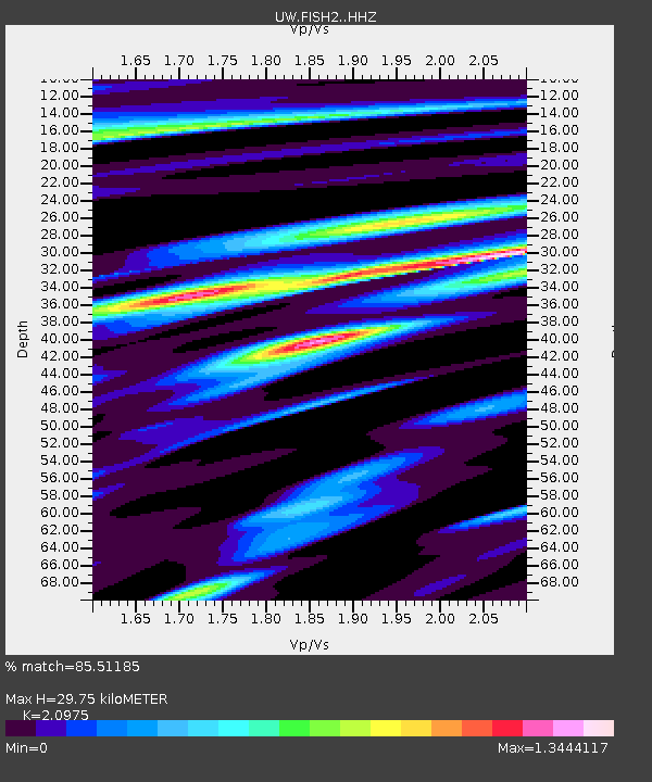
| Estimated Moho Depth: |
29.75 km |
| Estimated Crust Vp/Vs: |
2.10 |
| Assumed Crust Vp: |
6.566 km/s |
| Estimated Crust Vs: |
3.13 km/s |
| Estimated Crust Poisson's Ratio: |
0.35 |
|
| Radial Match: |
85.51185 % |
| Radial Bump: |
396 |
| Transverse Match: |
70.73299 % |
| Transverse Bump: |
400 |
| SOD ConfigId: |
28764291 |
| Insert Time: |
2022-10-06 06:36:55.420 +0000 |
| GWidth: |
2.5 |
| Max Bumps: |
400 |
| Tol: |
0.001 |
|

Signal To Noise
| Channel | StoN | STA | LTA |
| UW:FISH2: :HHZ:20220922T06:22:04.070007Z | 4.3240733 | 5.9433165E-7 | 1.3744717E-7 |
| UW:FISH2: :HHN:20220922T06:22:04.070007Z | 1.7057973 | 3.056831E-7 | 1.7920247E-7 |
| UW:FISH2: :HHE:20220922T06:22:04.070007Z | 0.7707097 | 2.2502375E-7 | 2.919695E-7 |
| Arrivals |
| Ps | 5.3 SECOND |
| PpPs | 13 SECOND |
| PsPs/PpSs | 18 SECOND |


