You are here: Home > Network List > UW - Pacific Northwest Regional Seismic Network Stations List
> Station HOOD Mt Hood Meadows, OR CREST BB SMO > Earthquake Result Viewer
HOOD Mt Hood Meadows, OR CREST BB SMO - Earthquake Result Viewer
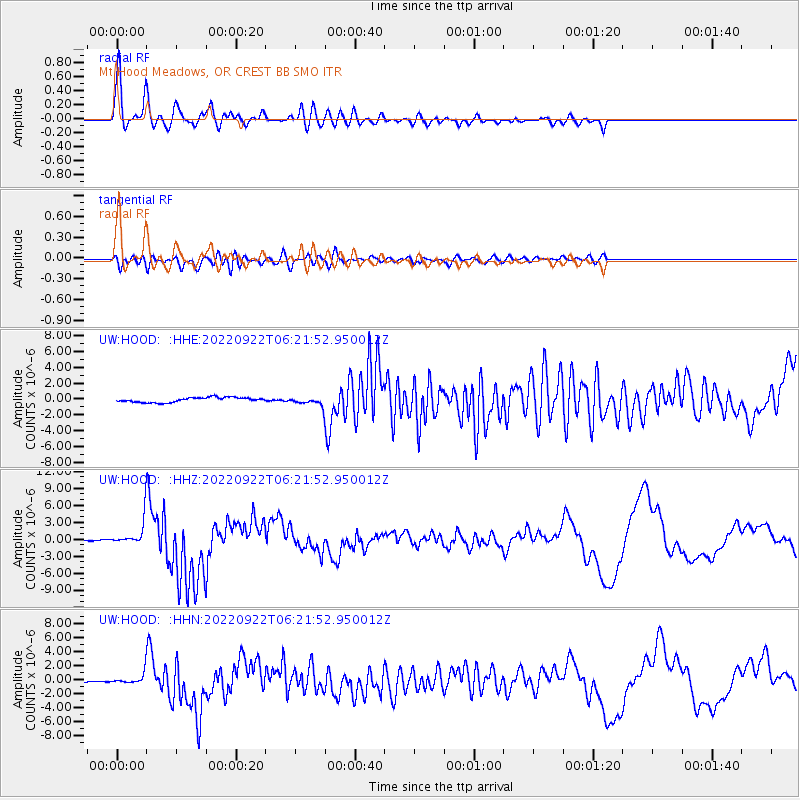
| Earthquake location: |
Michoacan, Mexico |
| Earthquake latitude/longitude: |
18.4/-102.9 |
| Earthquake time(UTC): |
2022/09/22 (265) 06:16:11 GMT |
| Earthquake Depth: |
61 km |
| Earthquake Magnitude: |
6.8 mww |
| Earthquake Catalog/Contributor: |
NEIC PDE/at |
|
| Network: |
UW Pacific Northwest Regional Seismic Network |
| Station: |
HOOD Mt Hood Meadows, OR CREST BB SMO |
| Lat/Lon: |
45.32 N/121.65 W |
| Elevation: |
1520 m |
|
| Distance: |
31.1 deg |
| Az: |
333.916 deg |
| Baz: |
143.718 deg |
| Ray Param: |
0.07909724 |
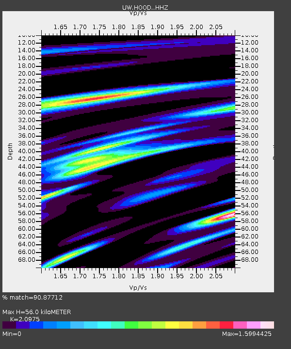
| Estimated Moho Depth: |
56.0 km |
| Estimated Crust Vp/Vs: |
2.10 |
| Assumed Crust Vp: |
6.597 km/s |
| Estimated Crust Vs: |
3.145 km/s |
| Estimated Crust Poisson's Ratio: |
0.35 |
|
| Radial Match: |
90.87712 % |
| Radial Bump: |
400 |
| Transverse Match: |
73.54944 % |
| Transverse Bump: |
400 |
| SOD ConfigId: |
28764291 |
| Insert Time: |
2022-10-06 06:37:09.542 +0000 |
| GWidth: |
2.5 |
| Max Bumps: |
400 |
| Tol: |
0.001 |
|
Signal To Noise
| Channel | StoN | STA | LTA |
| UW:HOOD: :HHZ:20220922T06:21:52.950012Z | 22.14439 | 1.8350055E-6 | 8.286548E-8 |
| UW:HOOD: :HHN:20220922T06:21:52.950012Z | 3.6037097 | 5.947013E-7 | 1.6502476E-7 |
| UW:HOOD: :HHE:20220922T06:21:52.950012Z | 1.5140077 | 4.598249E-7 | 3.037137E-7 |
| Arrivals |
| Ps | 10 SECOND |
| PpPs | 24 SECOND |
| PsPs/PpSs | 34 SECOND |


