You are here: Home > Network List > UW - Pacific Northwest Regional Seismic Network Stations List
> Station NEMA NEMA Site, Pacific County, WA, USA > Earthquake Result Viewer
NEMA NEMA Site, Pacific County, WA, USA - Earthquake Result Viewer
| Earthquake location: |
Michoacan, Mexico |
| Earthquake latitude/longitude: |
18.4/-102.9 |
| Earthquake time(UTC): |
2022/09/22 (265) 06:16:11 GMT |
| Earthquake Depth: |
61 km |
| Earthquake Magnitude: |
6.8 mww |
| Earthquake Catalog/Contributor: |
NEIC PDE/at |
|
| Network: |
UW Pacific Northwest Regional Seismic Network |
| Station: |
NEMA NEMA Site, Pacific County, WA, USA |
| Lat/Lon: |
46.50 N/123.75 W |
| Elevation: |
509 m |
|
| Distance: |
32.9 deg |
| Az: |
333.068 deg |
| Baz: |
141.498 deg |
| Ray Param: |
0.07832342 |
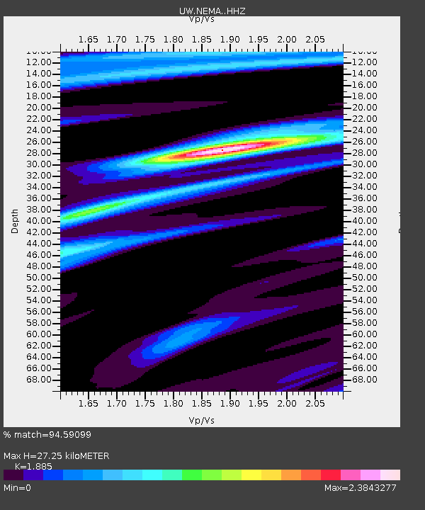
| Estimated Moho Depth: |
27.25 km |
| Estimated Crust Vp/Vs: |
1.88 |
| Assumed Crust Vp: |
6.566 km/s |
| Estimated Crust Vs: |
3.483 km/s |
| Estimated Crust Poisson's Ratio: |
0.30 |
|
| Radial Match: |
94.59099 % |
| Radial Bump: |
400 |
| Transverse Match: |
73.72536 % |
| Transverse Bump: |
400 |
| SOD ConfigId: |
28764291 |
| Insert Time: |
2022-10-06 06:37:36.129 +0000 |
| GWidth: |
2.5 |
| Max Bumps: |
400 |
| Tol: |
0.001 |
|

Signal To Noise
| Channel | StoN | STA | LTA |
| UW:NEMA: :HHZ:20220922T06:22:08.899994Z | 3.5764048 | 4.994465E-7 | 1.3965045E-7 |
| UW:NEMA: :HHN:20220922T06:22:08.899994Z | 1.138029 | 1.707215E-7 | 1.5001508E-7 |
| UW:NEMA: :HHE:20220922T06:22:08.899994Z | 2.0961194 | 2.2464735E-7 | 1.0717298E-7 |
| Arrivals |
| Ps | 4.0 SECOND |
| PpPs | 11 SECOND |
| PsPs/PpSs | 15 SECOND |


