You are here: Home > Network List > UW - Pacific Northwest Regional Seismic Network Stations List
> Station PASS Maple Falls, WA, USA > Earthquake Result Viewer
PASS Maple Falls, WA, USA - Earthquake Result Viewer

| Earthquake location: |
Michoacan, Mexico |
| Earthquake latitude/longitude: |
18.4/-102.9 |
| Earthquake time(UTC): |
2022/09/22 (265) 06:16:11 GMT |
| Earthquake Depth: |
61 km |
| Earthquake Magnitude: |
6.8 mww |
| Earthquake Catalog/Contributor: |
NEIC PDE/at |
|
| Network: |
UW Pacific Northwest Regional Seismic Network |
| Station: |
PASS Maple Falls, WA, USA |
| Lat/Lon: |
49.00 N/122.09 W |
| Elevation: |
174 m |
|
| Distance: |
34.2 deg |
| Az: |
337.377 deg |
| Baz: |
146.318 deg |
| Ray Param: |
0.07768791 |
| Estimated Moho Depth: |
40.0 km |
| Estimated Crust Vp/Vs: |
1.64 |
| Assumed Crust Vp: |
6.566 km/s |
| Estimated Crust Vs: |
3.992 km/s |
| Estimated Crust Poisson's Ratio: |
0.21 |
|
| Radial Match: |
90.7367 % |
| Radial Bump: |
400 |
| Transverse Match: |
71.1963 % |
| Transverse Bump: |
400 |
| SOD ConfigId: |
28764291 |
| Insert Time: |
2022-10-06 06:37:45.279 +0000 |
| GWidth: |
2.5 |
| Max Bumps: |
400 |
| Tol: |
0.001 |
|
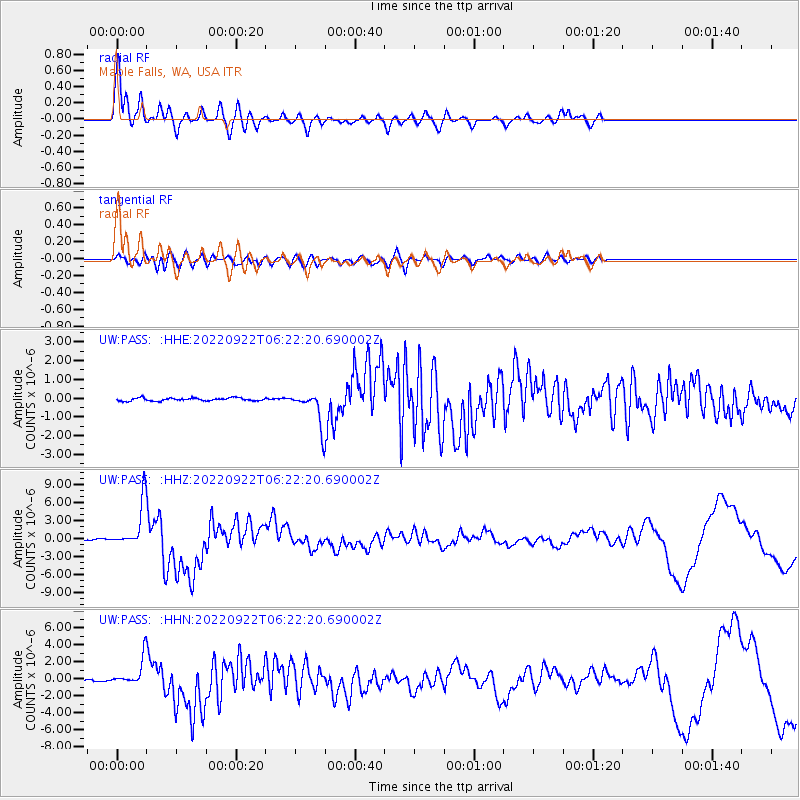
Signal To Noise
| Channel | StoN | STA | LTA |
| UW:PASS: :HHZ:20220922T06:22:20.690002Z | 41.070404 | 3.5843393E-6 | 8.727305E-8 |
| UW:PASS: :HHN:20220922T06:22:20.690002Z | 15.797969 | 1.4866029E-6 | 9.410089E-8 |
| UW:PASS: :HHE:20220922T06:22:20.690002Z | 10.685912 | 8.320625E-7 | 7.786537E-8 |
| Arrivals |
| Ps | 4.3 SECOND |
| PpPs | 15 SECOND |
| PsPs/PpSs | 19 SECOND |


