You are here: Home > Network List > UW - Pacific Northwest Regional Seismic Network Stations List
> Station TNSKT Tonasket, WA, USA > Earthquake Result Viewer
TNSKT Tonasket, WA, USA - Earthquake Result Viewer
| Earthquake location: |
Michoacan, Mexico |
| Earthquake latitude/longitude: |
18.4/-102.9 |
| Earthquake time(UTC): |
2022/09/22 (265) 06:16:11 GMT |
| Earthquake Depth: |
61 km |
| Earthquake Magnitude: |
6.8 mww |
| Earthquake Catalog/Contributor: |
NEIC PDE/at |
|
| Network: |
UW Pacific Northwest Regional Seismic Network |
| Station: |
TNSKT Tonasket, WA, USA |
| Lat/Lon: |
48.72 N/119.44 W |
| Elevation: |
395 m |
|
| Distance: |
33.1 deg |
| Az: |
339.795 deg |
| Baz: |
150.316 deg |
| Ray Param: |
0.078237 |
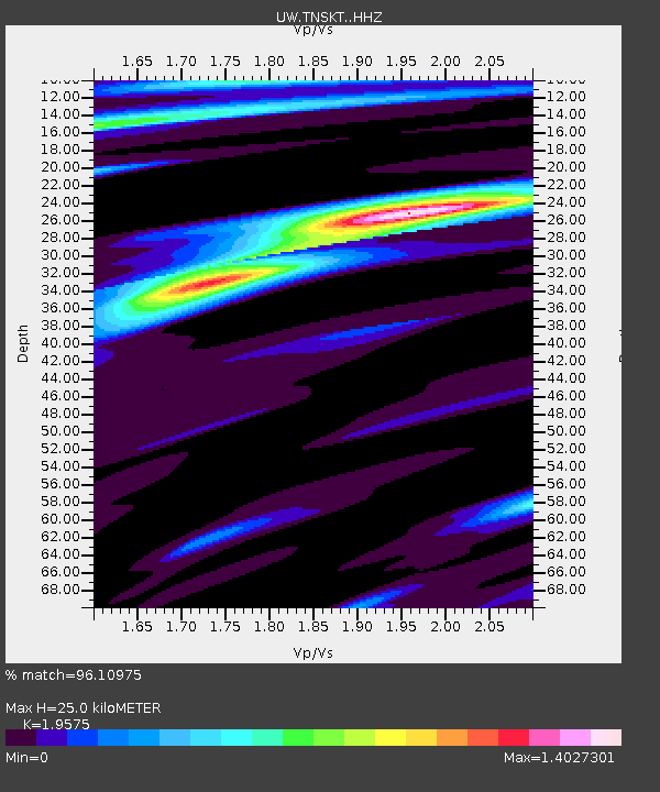
| Estimated Moho Depth: |
25.0 km |
| Estimated Crust Vp/Vs: |
1.96 |
| Assumed Crust Vp: |
6.419 km/s |
| Estimated Crust Vs: |
3.279 km/s |
| Estimated Crust Poisson's Ratio: |
0.32 |
|
| Radial Match: |
96.10975 % |
| Radial Bump: |
317 |
| Transverse Match: |
67.61681 % |
| Transverse Bump: |
400 |
| SOD ConfigId: |
28764291 |
| Insert Time: |
2022-10-06 06:39:34.544 +0000 |
| GWidth: |
2.5 |
| Max Bumps: |
400 |
| Tol: |
0.001 |
|

Signal To Noise
| Channel | StoN | STA | LTA |
| UW:TNSKT: :HHZ:20220922T06:22:10.709991Z | 34.869484 | 2.6957716E-6 | 7.731034E-8 |
| UW:TNSKT: :HHN:20220922T06:22:10.709991Z | 19.804892 | 1.3838667E-6 | 6.987499E-8 |
| UW:TNSKT: :HHE:20220922T06:22:10.709991Z | 9.667283 | 7.4479937E-7 | 7.7043296E-8 |
| Arrivals |
| Ps | 4.0 SECOND |
| PpPs | 11 SECOND |
| PsPs/PpSs | 15 SECOND |


