You are here: Home > Network List > UW - Pacific Northwest Regional Seismic Network Stations List
> Station LMONT Lamont School, Lamont, WA, USA > Earthquake Result Viewer
LMONT Lamont School, Lamont, WA, USA - Earthquake Result Viewer
| Earthquake location: |
Michoacan, Mexico |
| Earthquake latitude/longitude: |
18.4/-102.9 |
| Earthquake time(UTC): |
2022/09/22 (265) 06:16:11 GMT |
| Earthquake Depth: |
61 km |
| Earthquake Magnitude: |
6.8 mww |
| Earthquake Catalog/Contributor: |
NEIC PDE/at |
|
| Network: |
UW Pacific Northwest Regional Seismic Network |
| Station: |
LMONT Lamont School, Lamont, WA, USA |
| Lat/Lon: |
47.20 N/117.90 W |
| Elevation: |
598 m |
|
| Distance: |
31.3 deg |
| Az: |
340.116 deg |
| Baz: |
151.729 deg |
| Ray Param: |
0.07902216 |
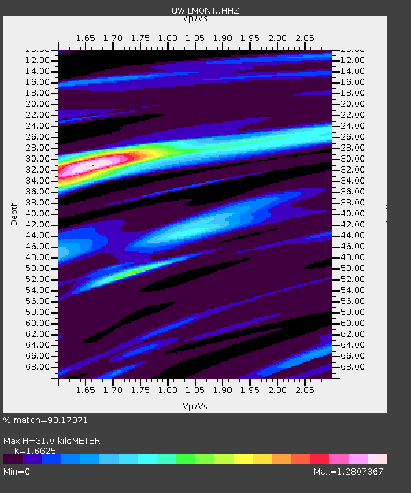
| Estimated Moho Depth: |
31.0 km |
| Estimated Crust Vp/Vs: |
1.66 |
| Assumed Crust Vp: |
6.571 km/s |
| Estimated Crust Vs: |
3.952 km/s |
| Estimated Crust Poisson's Ratio: |
0.22 |
|
| Radial Match: |
93.17071 % |
| Radial Bump: |
293 |
| Transverse Match: |
52.11407 % |
| Transverse Bump: |
400 |
| SOD ConfigId: |
28764291 |
| Insert Time: |
2022-10-06 06:39:41.767 +0000 |
| GWidth: |
2.5 |
| Max Bumps: |
400 |
| Tol: |
0.001 |
|

Signal To Noise
| Channel | StoN | STA | LTA |
| UW:LMONT: :HHZ:20220922T06:21:54.720001Z | 40.102753 | 3.4123361E-6 | 8.508982E-8 |
| UW:LMONT: :HHN:20220922T06:21:54.720001Z | 14.762099 | 2.279622E-6 | 1.5442397E-7 |
| UW:LMONT: :HHE:20220922T06:21:54.720001Z | 3.9505398 | 1.4312408E-6 | 3.622899E-7 |
| Arrivals |
| Ps | 3.4 SECOND |
| PpPs | 11 SECOND |
| PsPs/PpSs | 15 SECOND |


