You are here: Home > Network List > XA95 - Missouri to Massachusetts Transect Stations List
> Station MM04 LeRaysville, Pennsylvania > Earthquake Result Viewer
MM04 LeRaysville, Pennsylvania - Earthquake Result Viewer
| Earthquake location: |
Kuril Islands |
| Earthquake latitude/longitude: |
44.6/149.4 |
| Earthquake time(UTC): |
1995/12/03 (337) 18:01:08 GMT |
| Earthquake Depth: |
33 km |
| Earthquake Magnitude: |
6.6 MB, 8.0 MS |
| Earthquake Catalog/Contributor: |
WHDF/NEIC |
|
| Network: |
XA Missouri to Massachusetts Transect |
| Station: |
MM04 LeRaysville, Pennsylvania |
| Lat/Lon: |
41.85 N/76.20 W |
| Elevation: |
473 m |
|
| Distance: |
84.8 deg |
| Az: |
32.395 deg |
| Baz: |
329.164 deg |
| Ray Param: |
0.04519823 |
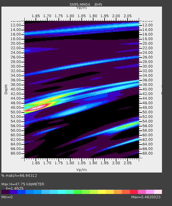
| Estimated Moho Depth: |
47.75 km |
| Estimated Crust Vp/Vs: |
1.65 |
| Assumed Crust Vp: |
6.121 km/s |
| Estimated Crust Vs: |
3.704 km/s |
| Estimated Crust Poisson's Ratio: |
0.21 |
|
| Radial Match: |
96.94312 % |
| Radial Bump: |
128 |
| Transverse Match: |
95.27852 % |
| Transverse Bump: |
187 |
| SOD ConfigId: |
29242 |
| Insert Time: |
2010-02-26 17:44:59.903 +0000 |
| GWidth: |
2.5 |
| Max Bumps: |
400 |
| Tol: |
0.001 |
|
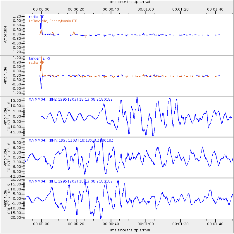
Signal To Noise
| Channel | StoN | STA | LTA |
| XA:MM04: :BHN:19951203T18:13:08.218018Z | 1.1684387 | 2.1998906E-6 | 1.8827608E-6 |
| XA:MM04: :BHE:19951203T18:13:08.218018Z | 1.2187849 | 2.840172E-6 | 2.330331E-6 |
| XA:MM04: :BHZ:19951203T18:13:08.218018Z | 0.9741609 | 2.782806E-6 | 2.8566183E-6 |
| Arrivals |
| Ps | 5.2 SECOND |
| PpPs | 20 SECOND |
| PsPs/PpSs | 25 SECOND |


